
 The South African
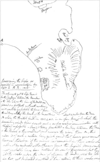
Some years ago, while trying to establish what documentation the Royal Engineers Museum at Chatham might have relating to the first and second occupations of the Cape by the British I was told through a contact that all they had was the following note. Readers may be interested in what it had to say and in my conclusion as to the identity of the mysterious 'Captain E RE'. I am grateful to the Museum for their agreement for me to have it published, with due acknowledgement of their ownership. The note's reference number is 2001-132:

The only way to get to Cape Town is by the passage between the mountains and the sea, there is a line of redoubts placed here, aud there is a footpath not worth mentioning as it would be impossible to force it from Hood Bay along the back of the mountains.
A. where the British landed in 1803, 4, or 5, in an open bay about 14 miles from the town into which the prevailing winds blow and create such a surf as renders communication with shippiug impossible. Craig's Tower prevented a landing between the town and river and they could not land nearer the river than A. This river is of such a nature, being quicksand, that heavy guns cannot traverse it. Therefore, if the enemy had remained in their works, which could not be reduced without heavy guns, the English Army would most probably have been destroyed for want of provisions. But they left the works with the idea of opposing the landing, and were too late [... to return to their fortifications] then got defeated and instead of their retiring to their works went up the country with the idea of cutting off our supplies. The line of defence consists of old works improved and rendered formidable by good escarps and ditches, consisting of four redoubts within easy musketry distance, one flank on a precipice and the other on the sea. The approach to them is enfiladed by a battery as expressed and Craig's Tower.
B. Hood's Bay is perfectly secure but too small for a fleet. The proper measures for taking the Cape is to land a small force at Hood's Bay aud from thence secure a remarkably strong pass. This is somewhere in the country between that and the Cape, which a very small force will defence then secure Mussem [Muizenberg] only about six miles from Hood's Bay. Here will be your regular communication with shipping, and from thence you will carry on your operations and heavy guns etc. against the town. A position may be taken up which will cut off the enemy's communication with the country. Mussem is reckoned about 40 miles from A and dificult country to get through.
When the British were formerly in possession of the Cape it was seen by two or three people that a battery at B would render the landing in Hood's Bay impossible. But it was left undone in case of our wanting to retake it after giving it up, and on consideration that it might be done in any emergency.
There is a large farm at Hood's Bay where, if the landing were effected very suddenly, a quantity of cattle and horses might be seized for the guns etc.
End of box

Notes:
1. I have not altered the writer's spelling or punctuation.
2. A at the open bay is Losperd's Bay and is 'where the British
landed in 1803,4 or 5' - a curious mistake to have made
in 1808 when this conversation was recorded. In fact, Major-General
David Baird landed his force at Losperd's Bay on
6 January 1806.
3. The river between A and Craig's Tower is called Sandy River
on the sketch map accompanying this note. It is identified
with Salt River.
4. Hood or Hood's Bay is Hout Bay.
5. The remarkable, strong pass is Constantia Nek.
6. 'Mussem' is Muizenberg, and lies 14 miles (22,5 km) from
Cape Town, not the 40 miles (64,3 km) given in the text. The
captain, RE, as a trained engineer, would not have made
such a gross error. Thus, it is more likely that the person
who wrote down this conversation must have misheard the
captain, especially given that 'fourteen' and 'forty' sound very
much alike when spoken.
7. The sketch map shows a battery in Hout Bay
where the 'little Gibraltar' battery was builtin 1794, but,
according to Theal's History ofSouthAffica before
1795 (Vol III/Star Vol IV,p 317), it was not provided with
any armament. This sketch map is only a crude outline
drawn by the note's writer, and is orientated to the south.
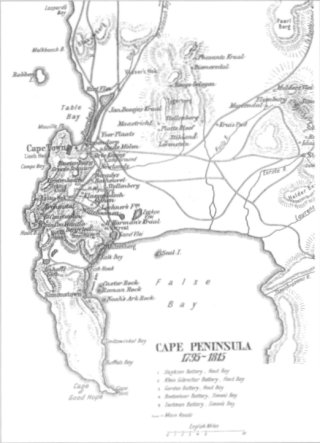
For comparison, I have included a more conventionally
orientated map (ie to the north) from Map 9A in
Professor Walker's Historical Atlas of South Africa,
published by Oxford University Press in 1922.
It is interesting to note that Elphinstone is mentioned in Theal's Records of the Cape Colony, Vol I(1793-6, p 146) as the second signatory under Captain George Bridges, RE, on the receipt for the Inventory of Buildings etc at the surrender of the Cape of Good Hope to the British, signed at the Castle on 20 September 1795. The Dutch signatories were Major of Artillery, George Coenraad Kuchler and Captain of Engineers, Louis Michel Thibault. Both Bridges and Elphinstone had come to the Cape with the British force sent there in 1795.
Elphinstone remained at the Cape until he left with the supporting force sent from there tojoin the main force sent from India in 1801 under Major-General David Baird to help forestall Napeleon's projected expedition to India from Egypt. He was back in England from the disastrous expedition to the River Plate in South America in 1807, fortuitously too late to have joined the British landing there. He was back again in England at the time of the conversation reported above, before he was sent out to the Iberian Peninsula to take part in the campaign there against Napoleon Bonaparte. He gets only the briefest and incomplete mention in Peter Philip's British Residents at the Cape in 1795 (David Philip, CapeTown, 1981). This reference simply repeats a mention of Elphinstone in the African Court Calendar for l80l, re-issued by the South African Library in Cape Town in 1970.
I cannot close without gratefully acknowledging the help that I received from Mrs Maggie Magnusson, the assistant librarian of the Royal Engineers Library, with details she sent me from Captain Conolly's Roll
Return to Journal Index OR Society's Home page
South African Military History Society / scribe@samilitaryhistory.org