
 The South African
by J P Pennefather
Professional Land and Mine Surveyor, RustenburgPlanning and the execution of military operatious, defensive and offensive, tactical and strategical, would be impossible without maps. In fact, in the past, considerable mapping was done for military purposes, and mapping activities have been greatly stimulated and advanced by the wars which have taken place over the last hundred years.
The Second World War (1939-l945), coming as it did after advances in aviation and photogrammetry, greatly eclipsed all previous wars in the extent of its effect upon map making. Vast areas were flown over, photographed and mapped, new maps were produced and old ones were reproduced for the use of military planners and for those directing the political, economic, and psychological phases of the war. During the Second World War, the armed forces of the United States are said to have printed about 650 million copies of some 57 000 different maps.(2) During the war, the first flying bomb (V1) was identified from an aerial photograph taken by the Royal Air Force of Peenemunde on the Baltic coast. Later, during the 1962 crisis, U2 photographic spy plane intelligence revealed the presence of offensive Soviet missiles in Cuba and the advent of earth orbiting satellites, satellite photography, using infra-red, laser, and radar scanning techniques, has made available very accurate current information for intelligence and mapping purposes. Coupled with this is the advance to Global Positioning Survey System technology (GPS) and the state-of-the-art techniques used during the Gulf War. Progress in this field can only be described as phenomenal; in fact, virtually nothing can be safely concealed from the 'eye in the sky'.
Before discussing mapping at the time of the Anglo-Boer War (1899-1902), it would be to advantage to take note of the intent and purpose of intelligence in general and, in particular, its utilization in the conduct of military operations. An intelligence operation can be defined as the process by which governments, military groups, business and other organizations systematically collect and evaluate information for the purpose of discovering the capabilities and intentions oftheir rivals. With such intelligence, an organization can both protect itself from its adversaries nod at the same time exploit their weaknesses.(3) Strategic intelligence encompasses issues of national security as well as the political, economic and social trends ofthe target nation.(4) Militiry intelligence is developed by specially trained military or civilian analysts and includes knowledge ofthe strengt, weapons technology, and estimated military capability of the enemy. The first step to generating intelligence is the collection of information by overt and covert methods. This raw intelligence is then combined with related data by a process of evaluation. The product can then be used by the military commander in planning and conducting military operations. The 'Field Intelligence Department' of an army would have as its task the collection, evaluation, correlation and dissemination of intelligence relating to the actual field of battle to its own immediate commander and, of course, through the normal military channels to the higher headquarters and then the troops on the ground. Throughout history, the use of intelligence has made the difference between success and failure, victory and defeat. In its turn, an accurate, well-drawn map provides key elements in the planning of a military operation. It means going into battle with 'eyes open' rather than plodding on in the dark. That having been said, let us now take a giant step backwards to the period before the outbreak of the Anglo-Boer War in 1899 to study the intelligence capabilities and mapping achievements, or lack thereof, of the combatants in that conflict.
In spite of the fact that the British had been involved in southern Africa for the best part of the century, there was an acute shortage of maps available of the two Boer republics and even of their own British colonies. In Britain, this map shortage was regarded as one of the biggest military scandals of the war. The risk of war had been apparent for months and yet the outbreak of war in October 1899 found the British woefully unprepared in the field of intelligence.(5) In the 1890s, an attempt had been made to provide the British Army with an intelligence branch and in 1895 a Director of Military Intelligence had been appointed. With the outbreak of war, however, the intelligence staff comprised only eighteen officers while the comparable complement of the German Army was 150. One result of this official parsimony was that the intelligence staff had no means of drawing maps. At the top of the command structure, there was no General Staff to plan and think out fundamental questions of strategy and tactics. The British Intelligence Division was maintained at a cost of �1 1 000 per annum while a quarter of a million was spent by the German General Staff. Two officers were responsible for the entire Colonial Empire. In comparison, the Zuid-Afrikaansche Republiek, or Transvaal Republic, was at this time spending �90 000 per annum on intelligence. A bitter Punch jest, which appeared six months after the war began, castigated the standard of planning and its prerequisite of accurate information by defining a map as 'a chart upon which names are sprinkled without any special significance as to exact locality'.
An unsuccessful attempt had been made, with the co-operation of Sir Harry Escombe, the Premier of Natal, for the production of a map of southern Natal. The British force stationed in Estcourt had no maps until the end of November 1899, when copies of an ordinary map without contours were found in the Estcourt Public Library. On arrival from England to take command at Mooi River, Major-General Barton found that he had neither intelligence officers, guides, or maps.
The good visibility of the South African atmosphere could not compensate for the lack of information about the kopje and donga studded landscape in the early part of the war. The British High Command had yet to learn the valtie of reconnaissance and efficient scouting, and the limitations imposed thereon by the terrain, the range of the Mauser rifle, and Boer mobility and marksmanship.
Lord Roberts brushed aside excuses by the War Office that conducting surveys would have aroused Boer suspicions. He later stated that 'the probability of war was foreseen about the month of February 1899, giving ample time for preparing maps'. General Buller, who had been at the War Office during those crucial years, wrote in one of his despatches of the difficulty of conducting operations in 'an unknown country'.(7) This statement is rather ludicrous and a general negligence presumably prompted Chamberlain to say that he could not trust himself to say what he thought of the War Office.
Apart from the lack of maps on the Natal front, the failure of British intelligence in this field contributed to British disasters elsewhere. At the battle of Stormberg (10 December 1899), the map of the ground was reported to be utterly misleading and worse than useless. Not only was the contouring so incorrect that it gave a totally false impression of the configuration of the hills, but distances and roads were also inaccurately represented.(8) At the battle of the Modder River, the British entered the action with little knowledge of the exact location of the Boer forces. Furthermore Lord Methuen's maps and intelligence indicated that the Modder aud Riet rivers could be forded at any point.(9) The intelligence on British maps was entirely at fault. The rivers were not fordable and the course of the Riet River had been improperly drawn; in fact, just about every detail on the roughly drawn map was inaccurate.(10) For this error, the British paid dearly for their victory on 28 November 1899 when Lord Methuen sent in a frontal attack on an enemy in a concealed, unknown, fortified position.(11) Faulty and poorly drawn maps and poor reconnaissance also contributed to the battles at Belmont (23 November 1899), Graspan (25 November 1899) and Magersfontein (11 December 1899) not going according to plan. At the battle of Belmont, one colonel of the Guards is reported to have said to a fellow officer, 'It seems to me that our leaders find the strongest position of the enemy, and then attack him on front.' The other officer replied, 'It appears to me that they attack him first, and find out his position afterwards.'(12)
Insufficient intelligence staff, the non-availability of reliable guides, and the desperate shortage of reliable maps, together with the outdated tactics employed by the British, foretold disaster on the battlefield. This was truly a case of 'fighting this war the way we won the last war'. How often has this not been the case in military history? In the Second World War, the German Blitzkrieg of 1939 smashed the Allied defences by the combined use of armour and air power, a case of the losers of the previous war using new revolutionary tactics to win the next battle.
On the Boer side during the Anglo-Boer War, the best map in every respect was 'Jeppe's Map of the Transvaal or South African Republic and surrounding Territories' in six sheets drawn to a scale of 1/476 000, with special insets for Pretoria and Johannesburg. This map was compiled by Mr Jeppe, chief draughtsman in the Surveyor-General's Office, Pretoria, using information from official farm surveys and other data. He was assisted by his son, who was subsequently killed at the battle of Spion Kop (24-25 January l900).(13)
During the war, the land office reproduced some existing maps of Griqualand West, Natal, Mashonaland and the Orange Free State, and also made blueprints from captured British maps. Few maps were issued to the officers, who were usually unable to understand them or really need them, as they had a good mental knowledge of the topography in any case.(14) General Joubert rarely used a map, though he had had some surveys for mapping purposes done on the Tugela and around Colenso and Ladysmith. The Boers had a natural aptitude for making the best use of te ground and were experts in the art of concealment and camouflage; perhaps as a result of their hunting and farming background. To quote Captain Reichman, the United States military attaché with the Boer forces: 'The Boers have a magnificent eye for ground, and General Botha seems to have the entire topography of the Transvaal in his head.'(15)
The British did, however, enjoy an unexpected stroke of good fortune when they seized a thousand Boer maps in Cape Town as contraband of war. The information gleaned from this source was of enormous assistance to Lord Roberts during his advance to Pretoria.(16)
Lord Methuen
Paul Sanford, Lord Methuen, commanded the British 1st
Division from 1899 to 1902. On arrival in Cape Town on
10 November 1899, he received instructions to organize
a column to relieve the besieged city of Kimberley. He
was 55 years old, had seen service in the Ashanti and
Egyptian campaigns and the Cape Colonial Government's
operations in the then Bechuanaland in 1884-5.
The Anglo-Boer War was the first time that Methuen
held an independent command of large body of troops,
about 8 000 men. He held overall command at the battles
of Belmont, Graspan, Modder River and the ignominious
defeat at Magersfontein which preceded the relief of
Kimberley. Thereafter, his 1st Division became an
integral part of Lord Kitchener's army. The 1st Division was
then involved in the great chase after De Wet and, from
then onwards, Methuen was constantly involved in the
guerrilla war in the Western Transvaal. It is during this
latter period that the 'Methuen Map' would have been
used by him.
The map in question was compiled in the Surveyor-General's Office in Pretoria under the direction of Major H M Jackson of the Royal Engineers, using information from Transvaal farm surveys. The key to the map indicates that it is one of some sixty maps prepared by the Mapping Section - Field Intelligence Department, at Army Headquarters, and photo-lithographed in Pretoria during March 1901. The total area covered by these maps stretched roughly from Zeerust in the west to an area beyond Machadodorp in the eastern Transvaal.
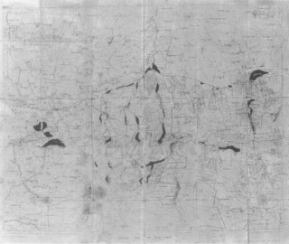
Figure 1. Map 51, 'Methuen Map'
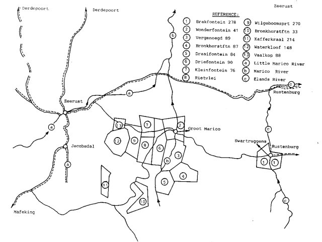
Figure 2. Map 51A, drawn to the scale of the original Methuen Map
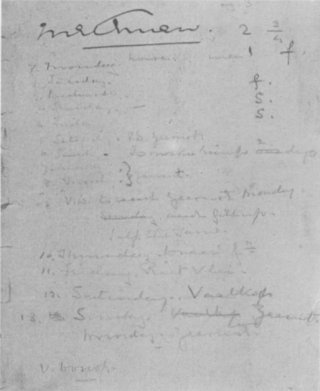
Figure 3. Methuen 's signature and notes, which appear on the inside cover of the map.
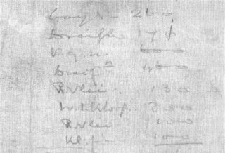
Figure 4. Note regarding numbers, which appears on the back of the map.
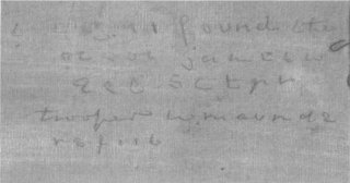
Figure 5. Note regarding Troopers Jameson and Maunde, which appears on the back of the map.
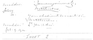
Figure 6. Copy of Methuen's signature from a despatch (McGregor Museum, Kimberley).
Maj H M Jackson served as surveyor-general of the Transvaal from 7 August 1903 to 27 February 1905. As it was customary that land surveyors sketched in the topography on farm survey diagrams, this information was available for inserting topographical detail on the compilation maps. The photo-lithograph process is one of the most widely used methods of printing. The ink image is first printed on a rubber cylinder, which then transfers the image to paper or linen. Lithography is particularly useful in the production of great numbers of large-sized sheets such as Map No 51. The Field Intelligence Department at Army Headquarters in Pretoria must have worked feverishly to produce the maps for operational use after the capture of that city on 5 June 1900.
Figure 5 refers to Private G Jameson from the 4th Battalion Essex Regiment, part of the 21st Corps of Mounted Infantry, who died of disease in Klerksdorp on 2 October 1901 and is buried there. Private W J Maunde, number unknown, of the 5th Battalion Imperial Yeomanry was killed in action at Kleinfontein on 24 October 1901, and was buried at Wilgerboomspruit. In later years, his body was exhumed and reburied in a mass grave in the military section of the Zeerust Cemetery.(18)
The circumscribed areas on the main map generally fall along the rivers and indicate areas of possible finer habitation and farming activity. The areas which have been inked in may have a particular significance and could be relevant to the farm burning policy being conducted by the British at that time.
The ownership of the writer's land survey practice in Rustenburg can be traced back to before 1900 and includes H E Schoch, B Muhl, G Greathead, P Grant Dalton and finally the writer's late father-in-law, C W Gracie. Schoch originally came from Rustenburg and was surveyor-general of the Transvaal from 1913 to l922.(19) The writer discovered the Methuen Map in the office records in about 1960. How did it get there? He would like to advance the hypothesis that it possibly came into the hands of Mr E Neuland, who was a medical orderly to Dr Karl von Rennenkampf of the Russian ambulance detachment of the Boer forces at the battle of Tweebosch on 7 March 1902, and who treated the wounded General Methuen. Mr Neuland settled in Rustenburg after the war (20) and may have passed the map on to one of the local land surveyors, probably Mr E Muhl, whose practice was bought by Mr Gracie in 1922.
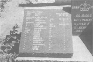
Figure 7. Tombstone of the mass grave at Zeerust Cemetery (Photo: E Wulfsohn)
Return to Journal Index OR Society's Home page
South African Military History Society / scribe@samilitaryhistory.org