
 The South African
by I B Copley and D C Panagos
During investigations by the authors of the large military complex of Rietfontein West - 17 miles (27km) west of Pretoria on the original Pretoria-Rustenburg Road - it became apparent that, from 31 December 1900, the 2nd Battalion The Lincolnshire Regiment had been in garrison in the area, with its headquarters at the Rietfontein West Camp.(1)
The camp had evolved over the preceding six months. The commanding site had been used as a bivouac by French's cavalry on 3/4 June 1900.(2) Later it had been used by units or columns travelling along the road between Pretoria and Rustenburg, usually via Commando Nek, since the road crossed the wooden bridge over the Crocodile River on General Hendrick Schoeman's farm at Hartbeespoort. The route was also followed by the telegraph line from Pretoria to Rustenburg (fig 1).
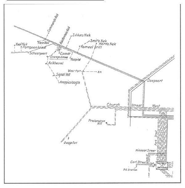
Fig. 1: Diagram of telephone/telegraph lines from Pretoria to Rietfontein 'Nek'. Fort Anderson is not connected telegraphically
The strategic importance of the site had been appreciated by Baden-Powell and it had been referred to as Baden-Powell's Headquarters Camp, as he had been responsible for laying out the original defensive works.(3) From the most westerly part of the ridge of four hills on the floor of the Moot, there are clear views to Commando Nek, 7 miles (11,6 km) away; the bridge over the Crocodile River, 2 miles (3,3 km) away; the Broederstroom Road, 3 miles (5 km) away; and Silkaatsnek, 3 miles (5 km) away - all within easy artillery range. Thus, traffic into and along the Moot westward from Smit's Nek could be controlled. Owing to its continuous occupation following the second battle of Silkaatsnek on 2 August 1900, the camp had evolved from a fortified communications post into a large garrison and convoy depot which boasted a 200-bed stationary hospital, No 39.(4)
On 31 December 1900, the 10th Regiment (Lincolnshires) relieved the 5th Regiment (Northumberland Fusiliers), having regrouped and recuperated after the Battle of Silkaatsnek on 11 July.(5) Headquarters and five companies of the Lincolnshires left Pretoria on 29 December (where they had been doing garrison and outpost duties) and they spent the night at 'Sandfort' [should read 'Zandfontein', west of Pretoria, or 'Westfort']. They arrived at Rietfontein on 30 December, on the same day that the remaining 'C', 'E' and 'H' companies left Pretoria. On the following day, HQ and the five companies proceeded (via the Paul Kruger Bridge and Commando Nek) to Bokfontein, a few miles north-west of Commando Nek, to relieve the Northumberland Fusiliers there and at Commando Nek. [Bokfontein appears to have been a convoy staging post approximately one day's wagon drive towards Rustenburg from Rietfontein. The exact site of this camp has not yet been located]. Meanwhile, 'C', 'E' and 'H' companies arrived at Rietfontein to relieve the Northumberland Fusiliers and to fill the gap, the HQ group having continued further west on the northern side of the Magaliesberg to Wolhuter's Kop on 1 January 1901.
At Wolhuter's Kop, they had joined General Clements' force, whom they accompanied to Elandskraal on 3 January before returning to Wolhuter's Kop on the following day. General Clements was responsible for passing on convoys to Rustenburg from his base at Wolhuter's Kop, a minor role after his unfortunate reverse at Nooitgedacht.(6)
The entry in the Lincolnshire's Regimental Diary (AB36) for 6 January reads:
'Back to Rietfontein where C & E companies joined the Battn, H Company being at South Hill [2 miles (3,3 km) south].'
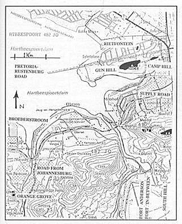
Fig. 2: Map showing the relationship of the South Hill forts to Rietfontein, the Crocodile River and 'Orange Grove' Fort.
Fig. 3: South Hill - a vertical masthead view
A summary of the Lincolnshire Regimental Diary (AB34) continues: 'Dec 29 to Mar 31 1901. The Battalion proceeded to Rietfontein and after some trekking settled down to Garrison [sic] the place finding detachments at South Hill, Fort Anderson (or Crocodile) and Commando Nek, (signed) J.W. Stringer Lieutenant 2 Lincolns.'
It had been assumed previously that Fort Anderson, which may have guarded the bridge or the adjacent river gorge through the Magaliesberg, lay submerged beneath the Hartbeespoort Dam (which was built in the 1920s)(8). The track which the authors had found was two metres wide at that stage and led to a shallow dip in the ridge before following a zig-zag route up to the ridge on the further (western) side. There, the foundations of an elongated octagonal blockhouse with an enclosed area of rough stone beneath and north of it could be seen (fig 4).
Fig. 4: Fort Anderson - an oblique masthead view
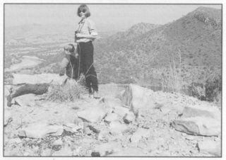
Fig. 5: Fort Anderson in relation to the Crocodile River
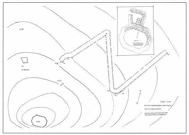
Fig. 6: Plan of Fort Anderson and surrounds, with contours sketched in
According to the Lincolnshire Regimental Diary: 'Major-General Barton, having assumed command of the Pretoria District - Vice Clements, visited Rietfontein, Commando Nek, Fort Anderson and South Hill on this date [5 April 1901] and inspected the defences at each place'.(9)
A track from Fort Anderson was found running down the gulley towards what is today the village of Meerhof joining up with the road through the Good Shepherd Mission, and continuing, presumably, over the Swartspruit to the military camp opposite. Hence Gen Barton would have reached Fort Anderson before South Hill on his visit.
It was with some surprise that a fork in the track, hidden by the long grass, was found on the South Hill-Fort Anderson track. This led to another small dip in the ridge and, on the far (or western) shoulder, a third blockhouse with a square foundation could be made out. The situation of the 'fort in-between' is very similar to that of Fort Anderson (fig 8).
The diary states that in May and June 1901 the battalion was involved in rounding up snipers and Boer cattle. The forts are not mentioned again. However, by November 1901, it is stated that 'Scheerpoort and Hekpoort, five posts in the valley south of the Magaliesberg range and west of Rietfontein [are] occupied by small detachments of Lincolns. The Battalion now occupies blockhouses at 16 separate posts with Headquarters at Rietfontein.' Grobblaars [sic] Pass (Breedts Nek), a pass about 5 miles (8 km) west of Nooitgedacht, was occupied by fifty men under Lt Bromhead. This represented the completion by the Royal Engineers of the Magaliesberg chain of forts, a project which had commenced in August 1901. In September, 'Lt Col Archdale 2 Lincoln Regt Commandant Rietfontein appointed Commandant of all outlying Posts in the Scheerpoort District with posts at Pampoens [sic] Kraal, Damhoek, Nooitgedacht and Kalkheuwel. Blockhouses being erected in Klein Nek and Zilikats Nek.' All these forts, except Kalkheuwel, were mentioned in the report by Lt Col R L Maxwell, RE, engineer in command.(10) Strangely, the three forts at South Hill were not mentioned and they seemingly did not warrant a telephone/telegraph line. A possible explanation for this was that these forts were in existence for many months before most of the Magaliesberg chain of forts. Some, such as the South Hill fort, may have been improved by Rice pattern additions.
The Lincolnshires were responsible for more forts before the general blockhouse system was introduced in the Magaliesberg. The entry in the diary for 28 June states: 'Major Day with three officers and 200 men C & H comes [sic] proceeded to Kalkheuwel to establish a new post there and build blockhouses & C. This has been a great stronghold of Boer snipers for a long time.'
On 23 July, the diary reads: 'A new post has been established at Orange Grove, the pass into the Broederstroom. Lt Bastard & 30 NCOs and men were sent out to occupy two small kopjes in the centre of the pass and a blockhouse is now in course of construction there.'
The blockhouse was placed on the eastern of the two hills. It remains a well-preserved double-storey blockhouse (along with the next one to the west at Hekpoort). Both the Orange Grove post (named after the many orchards in the Broederstroom valley at the time) and the one at Kalkheuwel were connected telegraphically with Rietfontein by a branch line, which continued on to Signal Hill and terminated at Knoppieslaagte. This would have provided easy, rapid, visual communication by heliograph between Johannesburg or Pretoria and the Magaliesberg chain (fig 1).
Still later in October 1901, an entry in the diary reads: 'A small nek (Klein Nek) a little West of Commando Nek occupied by B Coy under Lieuts Lyall and Richardson and four blockhouses built there .
Klein Nek is also known as Pampoen Nek. Presumably the forts were built by the engineers, since they are all of the Rice pattern type.
Discussion
It has been suggested that, during the construction of the line of forts on the Magaliesberg in the latter half of 1901, the defences at Rietfontein were upgraded, mainly by the cheaper Rice pattern method. This may have occurred at the South Hill forts and at Fort Anderson, but there is no evidence of this from the remains of the 'Fort-In-Between'.
Fig. 7: South Hill, looking across the Moot toward Klein Nek and Commando Nek.
The valley is now filled with the Hartebeespoort Dam.
From Wilson, With the Flag to Pretoria, Vol IV, wrongly labelled 'Kommando Nek'
If the South Hill forts did exist at the time that the Lincolnshires took over from the Northumberland Fusiliers (which seems probable, as the journal mentions that 'H' Coy was already at South Hill by 6 January), then it is possible that the original forts were built by the Fusiliers and Anderson may have been one of their officers. Unfortunately, neither the Fusiliers nor the Lincolns claim to have had an officer of that name serving in South Africa. Thus, he may have been an engineer (as yet unidentified). Although the two regiments concerned could not claim to have had an officer by the name of Anderson, there is one possible claimant to the title. On 28 February 1901, the Fusilier Regimental Gazette carried an article from 'our able correspondent' (who had been wounded at the battle of Nooitgedacht), stating that 'on the 18th [of December and five days after the battle], a convoy of 26 of our wounded men arrived from Nooitgedacht. Mr Anderson, our scripture reader, returned to Nooitgedacht with the first convoy on the 15th, and remained with the wounded till the return of the last convoy on the 18th December, having rendered valuable aid to many of our wounded during that period.'(11),(b)
As there does not appear to have been any other Anderson in the vicinity during the building of the defensive forts, the naming of one of the forts after him may have been a way of recognising his efforts during and after the battle, especially as he (being perhaps an unordained or lay preacher) would not have qualified for a military decoration.Unfortunately, the authors found no further information concerning this noble-spirited gentleman, other than a reference in the diary of Trooper J G B Clayton, who wrote [emphasis added by the authors]: 'On arrival (14th Dec) the ambulances had been emptied and despatched back to fetch the remaining wounded, of whom a great majority had been left behind - to minister to whose service a couple of doctors and a civilian Bible Reader, temporarily attached to the Northumberland Fusiliers, had remained behind. The gallantry of this act cannot be underestimated when it is known that they were under fire most of the time from both sides'. This is clearly a reference to the conspicuous gallantry of the Northumberland's Mr Anderson.(12) Clayton spent the following six weeks at the Rietfontein West complex and may have been part of the general body of support for naming the fort after Anderson, a unique event in blockhouse construction.
The functions of the South Hill group of forts seem to have been the following:
Visitors to the South Hill group of forts have commented on the fact that Fort Anderson and the 'Fort-in-between' are both overlooked by higher ground to the east. However, South Hill itself covers most of the high ground overlooking the 'Fort-in-between' and, to a lesser extent, Fort Anderson. The 'Fort-in-between' controls some of the intervening ground to Fort Anderson. On the southern side of all three forts, the ground is either very steep or sheer cliff, whilst the northern face of the ridge is in full view of 'Gun Hill' at Rietfontein.
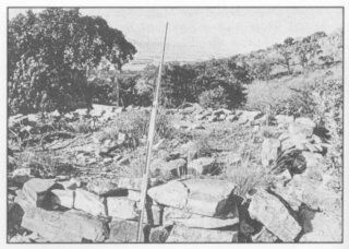
Fig. 8: The 'Fort-in-between'
As the 'Fort-in-between' shows no evidence of Rice pattern improvements, the possibility exists that it was abandoned or re-sited as Fort Anderson. This may explain why a third fort is never mentioned in the Lincolnshire records. There is no shortage of good building material in the form of rectangular quartzite blocks scattered all over the countryside.
If the three groups of forts at South Hill, Broederstroom and Kalkheuwel (a total of eight forts) were upgraded (presumably by the Royal Engineers), it seems strange that they were not included in the Maxwell list. That the Fusiliers were engaged in constructing sangars and blockhouses in late 1900 is confirmed by their gazette of 28 February 1901, in which it is stated: 'During our stay at Commando Nek, our time was spent in building sangars and blockhouses'. Not all of the Fusiliers were at Commando Nek and it is thus conceivable that their HQ based at Rietfontein West on the telegraph line, would have been similarly engaged in building fortifications designed to protect the southern ridge overlooking their camp. They had taken over Commando Nek from the Worcestershire Regiment on 16 December 1900 and were relieved by the Lincolns on 31 December. The forts at Kalkheuwel, eventually a complex of four guarded the access to the Magaliesberg region frog Johannesburg which had been the site of the ambush of French's flanking cavalry on 2 June 1900.(14)
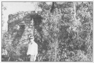
Fig. 9: The Broederstroom Fort
That the South Hill group did not escape systematic destruction along with the fortifications at Rietfontein West Camp and its 'Gun Hill' may have much to do with these structures having been completely forgotten. Their whereabouts were known only to a few local residents, whose sole concession to posterity during the development of the area was to name the street leading up to Gun Hill, which is now already half built over, Canonsingel.
Notes a. The Morse flag was also known as 'Wig-Wag'. The operator held a flag vertically and moved it 45 degrees to the right to indicate a dot and 90 degrees to the right to indicate a dash. The main disadvantage was that the signaller had to stand up, sometimes within rifle range of the enemy. b. Scripture reader - lector scriptorius - bible reader. No information has yet come to light concerning such a civilian having been attached to a regiment. However, the Carabiniers had with them a Carmelite monk, who distinguished himself during the ambush in Kalkheuwel Pass.(15) c. Masonry blockhouses at Commando Nek and Hekpoort, all of the same design, were completed by January 1901. This is the date which was scratched into the wet plaster of one of the loopholes in the crenellated roof of the Hekpoort Blockhouse. The construction of the Magaliesberg line of corrugated forts commenced in August 1901. The masonry blockhouse at Orange Grove, unlike the blockhouses mentioned above, did not have a crenellated roof, but resembles those at Quaggapoort and Klapperkop, by having a corrugated iron roof instead.
The forts at Orange Grove and Hekpoort escaped destruction whilst the four masonry blockhouses at Commando Nek (except the easternmost) were either stripped or blown up after the war, as were all the forts of the Magaliesberg chain. Metal sheets, posts and wire were given to or acquired by the local farming community.
ADDENDUM
Since the submission of the above article to the Military History Journal, a shoulder title 'W York' was picked up by the property manager some 100 metres north-west of Fort Anderson. It was found on the surface after a grass fire. No definite association between the West Yorkshire Regiment and the forts has been found, but the regiment is recorded as having been in the area on several occasions. Major Crossman of the West Yorkshires mentioned passing through Rietfontein in his unpublished diary (held at the National Army Museum, London). In addition, two 'trouser' or continuation buttons were found on the floor of the Fort Anderson blockhouse; one was damaged and the other was marked 'Harrison & Smith Ltd B'ham' - bringing to four the number of Birmingham manufacturers of brass continuation buttons found in the Rietfontein area. (Smith & Wright, manufacturers of other ranks' buttons, who were absorbed into Firmin & Sons in the 1960s, produced officer quality buttons, whilst the fourth button, associated with an artillery position, 'Gun Hill' at Rietfontein, is marked 'Player Birmingham'.
A small silver locket marked 'FWC Birmingham 1898' was also found on the floor of Fort Anderson.
REFERENCES
BIBLIOGRAPHY
Maurice, Sir F (ed), History of the War in South Africa 1899-1902 (MM Gove Hurst & Blackett, London 1908).
Robertson, I, (ed), Cavalry Doctor (Robertson, Constantia, 1975), [Condensation of original letter by Major AF Russel, MO, Scots Greys].
Lye, WF (ed), Andrew Smith's Diary (published for the South African Museum by AA Balkema, Cape Town, 1975).
St George's Gazette, Northumberland Fusiliers' Regimental Magazine, Ainwick Castle, Northumberland.
Yardley, JW, The Records of a Cavalry Regiment (6th Inniskilling Dragoon Guards), (Longmans Green, London,1904).
Unpublished Sources
Information not included in Lee's History of the l0th Foot, Vol II, (Gale & Polden, 1911). Regimental Diary 'T' Battery, Royal Horse Artillery.
Regimental Archives, Royal Artillery Institution, Old Royal Military Academy,
Woolwich, London. Clayton, JOB, 'Kitchener's Horse', Killie Campbell Museum, Durban.
Copley, IB, 'Rietfontein Military Camp and Hospital', unpublished manuscript submitted to the Military History Journal.
Maxwell, RL, 'Report of work done in the Pretoria District, 14th May 1902'. Regimental Archives; Library, Brompton Barracks, Chatham.
Acknowledgements and thanks:
The authors would like to express their appreciation for the assistance provided by the following:
Mr and Mrs D Cardin, Good Shepherd Mission, Meerhof (Fort Anderson).
Col Jack Clayton (SAAF rt'd), Waterkloof, Pretoria.
Mrs IB Copley, SA Military History Society.
Mr AIL Davies, Assistant Curator, Lincolnshire Life Museum, Lincoln.
Mr Basil Green, Evergreen Farm, Broederstroom (Orange Grove).
Maj M Jones, Regimental Secretary, The Royal Anglian Regt, Gibraltar Barracks, Bury St Edmunds (previously at RHQ, Sabroan Barracks, Lincoln)
Mrs J Lochner, Dept Neurosurgery, Medunsa.
Mrs M Magnuson, Assistant Librarian, Royal Engineers Library, Brompton Barracks, Chatham.
Capt and Mrs PHD Marr, Fusiliers Museum of Northumberland, Abbot's Tower, Alnwick Castle, Northumberland.
Mr and Mrs C Oliewski, Meerhof Farm, Meerhof, Hartbeespoort (South Hill).
Brigadier KA Timbers, Historical Secretary, The Royal Artillery Historical Trust, Woolwich.
Return to Journal Index OR Society's Home page
South African Military History Society / scribe@samilitaryhistory.org