
 The South African
(incorporating Museum Review)
by Jos Johnson & Murray Bridgeman
Background
Local tradition in the Koue Bokkeveld had it that there were two Anglo-Boer
War blockhouses east of the Olifants River in a remote valley about halfway
between Citrusdal and Ceres in the Western Cape. A photograph taken in
about 1974 showed one fairly solid circular stone structure, but the other
was said to have been a ruin prior to that time. They were thought to have
been built towards the end of the war following General Smuts' incursion
into the Cape, but their precise location and purpose were unknown. A visit
to the area in April 1991 located the first blockhouse, which is of an
unusual design, but failed to find the other.
The blockhouse today
The blockhouse is located 33 34'41" S, & 19 08'54" E.
It is situated on the end of a spur about 40 m from a perennial stream
which runs down from Oordmansvlei se Kloof to the Olifants River about
a kilometre to the west.
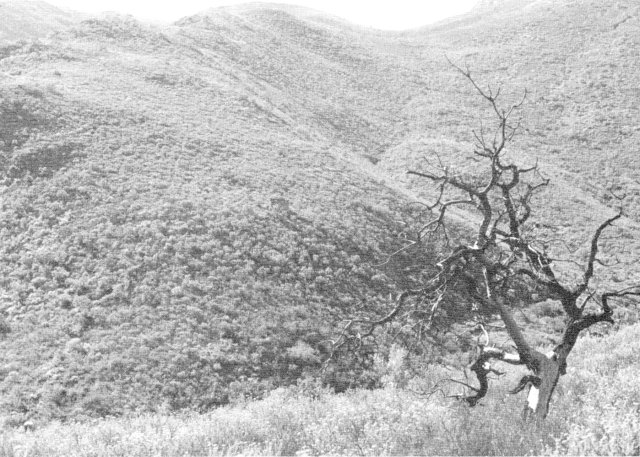
Blockhouse setting. The blockhouse is in the centre of the picture
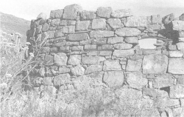
It is circular, and well built of shaped stone. It currently stands three metres high, but as there are a few single stones in the outer part of the wall it is likely that it originally had one more course, at least on the outside. The walls are just over 61 cm thick, with a low door which is only 42 cm wide on the inner side. Inside, there are regular holes for joists for a floor or gallery at 1,37 m above ground level, and the 16 regularly spaced gun ports (only 9 remain) are 91 cm above this. This would be suitable for someone kneeling, but not standing to fire. At the existing wall height there would have only been 1,60 m of protective stonework, which also suggests a further course of stones. The gun ports and supports for the stone arches were made of shaped, flat iron bars. The internal diameter of the blockhouse varies between 3,35 m and 3,48 m.
Comparison with other blockhouses
In some ways this structure resembles a Rice-pattern blockhouse, but
is made of stone and is slightly smaller. The Rice-type had an inside diameter
of 3,75 m, allowing for the corrugated iron caisson, and the protection
rose 1,88 m above the floor. The door in this example is similarly low,
but 19 cm narrower. Differences are the raised floor and the height of
the gun ports above the floor 1,3 m in a Rice-type.
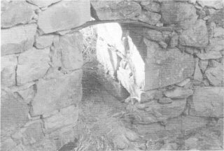
The entrance, as viewed from inside
There has been little deterioration since the photograph was taken in 1974, but a local farmer who saw the blockhouse in the 1940s says that at that time it still had a ridged corrugated iron roof, the form officially prescribed, though not always used, for the Rice-type blockhouse. No trace of this roof now remains, nor of the missing iron from the gun ports on the side where the top of the wall is missing. It is difficult to imagine who would have removed forty year old corrugated iron from such a remote place in the last fifty years.
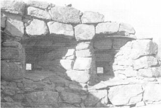
Gunports, as viewed from inside
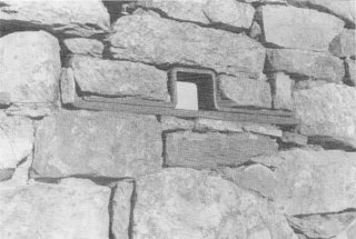
Details of gunport, as seen from outside
The remoteness of the location also suggests the reason for a Rice-pattern blockhouse not being built there, unlike the blockhouses on the Lamberts Bay - Calvinia line a little further north. The transporting of materials would have been very arduous, and stone in the area is abundant. The structure has therefore used the minimum of imported materials possible.
The purpose of the blockhouse
The blockhouse was clearly intended to hinder Smuts' movements in the
Cape in 1902. According to Denys Reitz(1), at the end of 1901 General Smuts
divided his force into smaller groups (p 279) to spread out, in some cases
several days apart. Reitz says that he travelled 'unnumbered miles from
south of the Olifants River to far beyond Calvinia'. Although mostly operating
further north along the Olifants River, south of van Rijnsdorp, Reitz does
say that some of the patrols went beyond Porterville 'to within sight of
Table Mountain' (p 280). when Judge de Villiers bought a farm in the area
in the early 1940s, General Smuts confirmed that he had indeed passed through
the area defended by the blockhouse. His comment was that the British always
built blockhouses after he had passed through an area.
The Olifants River was clearly of importance to Smuts' Commando. The location of the Blockhouse permits two possibilities for its purpose. Either it was to prevent use of the valley and perennial stream by part of the Boer commando, or it was to deter north-south movement east of the Olifants River.
The first of these is possible, but perhaps the less likely. There is abundant water in the area, and the upper parts of the kloof are very steep. While the area around and immediately above the block house is fairly level and fertile it would be difficult to penetrate much further upstream or to leave the valley in that direction. The second possibility is supported by the fact that at one time there was a path running somewhere through that area from the Ceres region to Keerom and Citrusdal.
No trace of this path now remains, but it was remembered by local farmers. This path would have been important for two reasons. Firstly, anyone travelling from north to south, east of the Olifants River, must at some point have crossed Diepkloof, an inaccessible valley a couple of kilometres to the south-east, and from the lie of the land the only practical route would have been up the valley to the east of the blockhouse. Secondly, the fynbos in that area is fairly thick - it took four to five hours of hard bundu-bashing to reach the blockhouse. By placing it where it is, the blockhouse had a reliable water supply, and effectively cut the north-south route east of the Olifants River.
The blockhouse lies well south of the Lamberts Bay - Clanwilliam - Calvinia blockhouse line built in the first quarter of 1902, but it is not clear how it relates to the Wellington-Porterville (?)-Modderfontein line to the west of the Olifants River marked on Bethel's map(2), but not shown on the map in the Times History.(3)
External view of the blockhouse, showing the gunports, one of which is broken away
Problems
The weakest point of the blockhouse is its isolation, and this may
be the reason for a second one in the vicinity. Its size precludes a large
permanent garrison (there were seven men in a Rice-pattern blockhouse,
possibly with some extra Black sentries). There are no obvious signs of
trenches, wire, or outworks, but the surrounding fynbos is pretty overgrown.
Water would have had to be carried about forty metres by hand, so a prolonged
siege would have been difficult; food would have been carried several kilometres
along the path. Interestingly, the local story is that the blockhouse was
garrisoned by coloured troops, and that one day the local farmers or a
rebel commando, such as that under Maritz, came along, ordered all of them
out and shot them. What basis there is for this story is not known, but
a carefully timed siege might well have produced a fairly rapid surrender,
and the Boers were not keen on the British arming black or coloured troops.
The legend thus makes for interesting speculation, and would not be out
of keeping with Maritz's handiwork. (see Commando, p299).
Notes
1. Reitz, Commando, (Faber, 1929) reprinted 1975.
2. E H Bethall, 'The Blockhouse System in the South African War' in RE
Professional Papers, XXX, 1904, pp 277-94.
3. L S Amery, ed. The Times History of the War in South Africa 1899-1902,
(London, 1906).
Return to Journal Index OR Society's Home page