
 The South African
by J.P.C. Laband
In technical language, all the British fortifications in Zululand were fieldworks, ‘constructed for purposes of temporary entrenchment only’,(2) as a tourist commented on seeing the ruinous state of Fort Crealock only three years after the end of the war. For unlike the stone laagers erected by the colonial government in some of Natal’s towns, and by the white settlers themselves in rural areas near the frontiers, they were not intended as permanent fortifications. The Natal laagers were constructed as abiding places of refuge from possible attack — especially by the neighbouring Zulu kingdom — for local settlers, their families, wagons, and servants. They were generally rectangular in shape, their perimeter varying between about 380 m (425 ft) and 230 m (755 ft), with loopholed masonry walls some 3 m high, flanked by two towers at opposite corners and surrounded by a ditch.(3) Many are still in use today — though suitably modified — for purposes ranging from gaols to cattle-laagers. Not so with the British fieldworks the functions of which were purely temporary. Sometimes, as at Col F. Wood’s camp at Khambula, or Lord Chelmsford’s camp on the banks of the White Mfolozi, they were designed to command the entrenched wagon-laager of an army encamped in the field. More often, they served to protect depots of stores along a British force’s line of communication and supply. Sometimes, they would fulfil both these roles in turn, as was the case with Fort Crealock. That fort was built ‘within the outer line of the entrenchment of the 1st Division ... in view of the subsequent demolition of the entrenchments and the retention of the fort as a depot station for a garrison not exceeding 300 men’(4).
This last point concerning the size of a garrison opens up an important issue. A problem facing a British column advancing into Zululand was how to defend a large amount of stores in its rear with the least possible number of men. Army standing orders laid down that companies were never to be broken up into detachments, so the least garrison in any one case had to be one company.(5) At the same time, experience in the field had shown that for a garrison’s defensive rifle-fire to be effective, the men should be ranged quite densely along the parapet of a fort, with about one rifle every 0.9 m (2 ft 9 inches) and a fifth of the garrison in reserve.(6) In practical terms, these considerations resulted in an average-sized garrison of two companies per fort in Zululand and determined the size of the work, though its perimeter usually allowed for an increase to three companies, and was not so large that at a pinch it could not be held by one company.(7)
What shape then did these works take? As temporary fieldworks, they were mainly built of earth, though stone was used when it was available. This meant that they have not stood up well to the ravages of the elements and of neglect and, especially in the coastal region, have been ploughed under by sugar-cane farmers. Often thrown up in remote parts of the countryside, their very sites have frequently been forgotten by all save those living in close proximity. It has therefore often proved difficult to establish details about their design and construction.
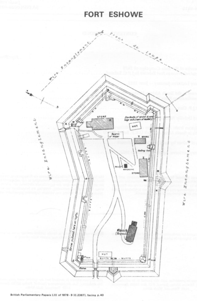
Fortunately, it has been possible through consultation of contemporary descriptions and maps, and with the aid of aerial photographs and local lore to locate the sites of all the more substantial British fieldworks in Zululand.(8) Of the twenty forts which originally existed, only two have totally disappeared, and four have been partially obliterated.(9) This leaves enough for generalizations about their design to be made from an examination of the remains in the field, slight as these vestiges often might be. But it is one thing to discern the basic trace of a work; it is another to ascertain details of design and construction. Here it is necessary to fall back on contemporary descriptions which, unhappily, mainly deal more with generalities than with the peculiarities of particular works. Only with the forts of the coastal plain are we reasonably fortunate. For there survive not only detailed diagrams and cross-sections of a number of them, but a close description of the construction of Fort Eshowe, and a justification for its particular design. It is because of the fullness of this report on Fort Eshowe, and because of the fort’s relatively good state of preservation, that that particular fieldwork, typical in so many of its features, has been selected as the most suitable model in the ensuing discussion on design and construction of the Zululand fieldworks.
The actual siting of a fieldwork was not much of a problem, mainly because of the Zulus’ relative lack of military sophistication. Lt-Col A. Harness, who served throughout the campaign from Isandlwana to Ulundi, commented on that score:
... opposed to an enemy without artillery, and with the worst description of firearms ... the advantages of a site, well drained, and possessing the somewhat rare recommendations of good water and grass, may justly be taken into consideration in favour of a somewhat indifferent military position.’(10)
When it came to the selection of a site, therefore, even such prime ‘qualifications’ as ‘good command of ground all round’, which Lord Chelmsford himself considered absolutely essential,(11) could be sacrificed with relative impunity in the interests, say, of the availability of fuel. Nor was it even necessary that there be a supply of water within the fort itself. Because the Zulus, on account of their normal tactics and problems of supply, were incapable of completely investing a fort or maintaining an assault beyond a few hours, it was quite sufficient if water were within easy distance of the fort, with the only proviso that it be within range of covering rifle-fire.(12)
Considerations such as these explain the choice of position for Fort Eshowe, which was in fact considered ‘weak and subject to great disadvantages in a military point of view’ by the Royal Engineers responsible for its construction, Captains Wynn and Courtney.(13) But to serve its primary and typical function in Zululand, that of protecting stores, it had to be built around the existing church and other buildings of the Norwegian Mission on the site, which had been selected to contain No. 1 Column’s supplies. This essential fact, coupled with the healthiness of the position and an ample supply of water from a nearby stream,(14) outweighed the disadvantage of the fort being commanded by hills on the northern and southern sides, and the problem posed by a wooded kloof and the valley of a stream on the western and northern flanks which could not be thoroughly commanded by fire from the fort’s parapet. Yet even such drawbacks could be nullified by effective design and construction. Concerning these Capt Bindon Blood, R.E., had these basic comments to make about the works in Zululand.
‘The fortification works carried out were all of the simplest description. The various forts ... were all designed on simple traces suitable to the ground ... with musket-proof parapets and usually triangular ditches. The ordinary military obstacles — abatis, entanglements, &c. — were used, where time and opportunity recommended them.’(15)
Obviously, as with Fort Eshowe, the configuration of the ground would be the final arbiter in determining the shape of a work, but whatever form this might take, every fort in Zululand fell within the technical category of being a redoubt, or ‘closed work of square or polygonal figure’.(16) The parapet of the redoubt can be defined as a bank of earth (though on occasion this could be stone, or earth reinforced with stone) moulded into suitable form for fire over its summit, yet providing protection for soldiers firing from behind it. When high enough, as at Fort Eshowe where it was generally six feet (a little under 2 m) though at some of the angles it was increased to eight and a half feet (a little over 2,5 m),(17) to allow soldiers to load with ease and security and to move in safety from place to place along it, it was necessary to introduce a banquette or step (accessible by an easy slope) standing upon which soldiers could fire over the parapet.
A parapet, such as at Eshowe, was formed artificially, the earth for its construction being derived from the ditch, dug immediately in front of, and parallel to it, which formed by its depth (it was seven foot deep (just over 2 m) at Fort Eshowe)(18) one of the principal obstructions to an advancing enemy(19). The construction of such works required heavy labour on the part of the soldiers, not made easier in the Anglo-Zulu War by the inadequate ‘intrenching tools’ with which they had been issued. All were made of very poor material, the picks and shovels being considered too small to be effective except for shelter-trenches in soft ground(20). Nevertheless, the troops clearly perservered and once they had dug the ditch and piled up the parapet, they faced the parapets with revetments of hurdles (portable rectangular wooden frames) to prevent their crumbling in the often rainy weather. But when the hurdles decayed, as they did at Fort Eshowe within two months,(21) or when time allowed, they were replaced by more permanent sod revetments. Access to the fort across the ditch was usually by bridge, and at Fort Eshowe there were three of them: a rolling bridge with a ‘wagon roadway’ that was run in every night; and two drawbridges for ‘foot passengers’.(22)
Normally, all redoubts whether square (the most simple shape) or polygonal, suffered from the same disadvantage: ‘dead’ salient angles, not covered by musketry fire from the straight faces of the parapets.(23) Usually, though, it was considered sufficient to place guns in the angles to command the ground in front of them.(24) Once again, this generalization is borne out by what occurred at Fort Eshowe: 7-pounder guns were mounted at the four salient angles. They were not placed in embrasures (openings in the parapet for guns) as these had the grave disadvantages of weakening the parapet and were difficult to construct and maintain. Rather, as was the British custom with redoubts, barbettes (platforms within the fort from which guns fired over the parapet) were constructed, the terreplein on which they were mounted being the standard three and a half feet (just over 1 m) below the crest of the parapet.(25) Blindages, or screens of sandbags resting on frames of timber, were provided for the protection of the gunners.(26)
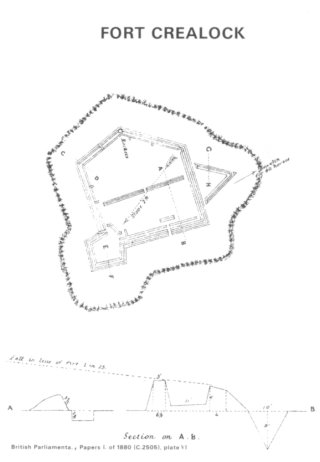
A further problem with the square or polygonal design of redoubts was the lack of opportunity it provided for flanking fire. Only in one case in Zululand, that of Fort Crealock, was a proper bastion (a pentagonal projection with its base at the angle of the main works) constructed. In a few cases, notably again at Fort Crealock, a ravelin (an outwork of two faces forming a salient angle outside the ditch of the main work, its open gorge covered by fire from the higher parapet to its rear) gave additional flanking fire, as well as providing a laager for horses or cattle.(27) Another expedient was suggested by the small size of the garrisons the British preferred to leave to guard their depots of stores. At Fort Eshowe, the existing buildings of the Mission dictated that the redoubt be built around them, even if the perimeter of 450 yards were thought to be strictly too large for the garrison of 1,300 men to hold(28). But with most others, where a mere company or two was supposed to guard great quantities of stores dumped in the open veld, it was impossible to man a continuous perimeter thrown up around them. The solution adopted was to construct a pair of mutually supporting small redoubts (generally half the size of single redoubts) which not only covered the stores placed between them, but provided each other with flanking fire. Well-preserved examples of this procedure survive at Fort Cambridge, Fort George, and Conference Hill. At the last two sites, the pentagonal redoubts are connected by breastworks, enclosing a diamond-shaped area between them(29).
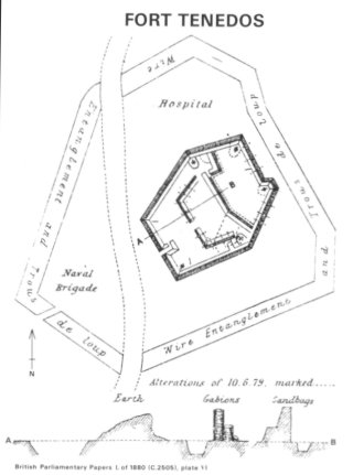
With a single redoubt, like Fort Eshowe, without bastions or ravelins, other means of creating opportunities for flanking fire had to be adopted. Fortunately, there were a number of standard methods in a Royal Engineer’s repertoire. An indented angle was formed in the long north face of Fort Eshowe, and a demi-bastion (as at Fort Tenedos) at the south-east corner to provide oblique fire. Caponiers (covered passages across the ditch) were thrown out on the southern and western faces to give some flanking fire, and a Gatling gun was mounted on a barbette on the long and exposed south face between the caponier and the south-eastern corner in order to strengthen it further. At the south-eastern angle a seventeen foot high (just over 5 m) stockade was constructed, with two levels of loopholes, to flank the ditch and command the valley to the south(30). Stockades, of course, had the great advantage over parapets in that the men behind them had a more effective command of the ground before them when firing through loopholes, than they could possibly have when firing over a parapet(31).
Related to problems of providing flanking fire were arrangements for security within the redoubt itself. The entrance to a redoubt, for example, would be made on its least exposed side, and be protected by a traverse placed behind it, which could in turn be connected to the main parapet by a stockade. (It was normal practice for gaps of about three inches to be left between the strong, pointed palisades of a stockade, the intervals being filled by shorter, square-cut palisades, the open spaces being employed as loopholes)(32). The entrance itself could be closed by gates or barriers(33). Whenever, as at Fort Eshowe, or any of the other larger forts in Zululand like Forts Crealock and Tenedos, there was a very large area within the perimeter, traverses and parados were constructed to protect the garrison from reverse or enfilading fire. At Fort Eshowe these were originally made of sacks and wagons, but were gradually replaced by proper sod works(34). Traverses, as at Fort Tenedos, could also serve to divide up the interior space of a redoubt to create a more secure and comfortable camping-ground for the garrison in part of the area. It was usual for magazines to be constructed in or against such traverses, which shielded them from the parapet(35). At Fort Newdigate, where there was a pair of supporting redoubts, different arrangements were made for the convenience and security of the garrison. Normally, if a convoy had arrived at the depot, the wagons would be drawn up in a square laager between the forts. But when they moved off to bring up fresh supplies, it was the practice to arrange the stores (e.g., sacks of mealies, biscuit boxes, boxes of tinned meat and vegetables, and bottles of lime-juice in crates) to form a covered way between the two redoubts for safe communication between the two halves of the garrison(36).
It was a general feature of temporary redoubts, as opposed to the complexes of permanent works that might be erected to fortify, say, the French city of Paris, that the ditch was too close to the parapet to be commanded from it(37). This was obviously a serious drawback, as the ditch was the last obstacle an enemy had to surmount before attempting to scale the parapet itself. Effective defence of the ditch was therefore related to the whole problem of providing flanking fire. The difficulty, as at Fort Eshowe, could be partially overcome by the fire from the caponiers, banquettes, and stockade. But portions of the ditch, especially that along the eastern face, were not covered by fire from the parapet(38). Other remedies, the application of which had become standardized, had to be resorted to in order to break up an attack by the enemy, for it was axiomatic that ‘in all works the efficiency of defence must mainly depend on the power of arresting the progress of the assailants at those points which are under the fire of the defencers’(39). Consequently, it was normal not only to fill the ditch with sharpened stakes and other obstacles (at Fort Eshowe the unflanked parts of the ditches were staked to make it more difficult for an enemy to rush the parapet)(40), but to raise a glacis. This was a mound of earth on the counterscarp (outer side) of the ditch, sloping gently upwards to the edge of the ditch. An assailant negotiating it would have the length of time he was fully exposed to fire from the parapet prolonged, as well as having his drop into the ditch increased(41).
In addition to the staked ditch and exposed glacis, other obstacles were commonly employed to delay the enemy under direct fire from the parapet. Very commonly used in Zululand, though not as it happened at Fort Eshowe, were abattis. These are formed of felled trees, their sharpened branches interlaced outwards, their trunks fastened both to the ground and each other by pickets and iron wire. Arranged in rows on the glacis around the fort, and thus easily swept with fire from the parapet, abattis greatly hindered assailants, and made it very difficult to surprise a garrison. Employed at Eshowe, as they were elsewhere, were wire entanglements and trous-le-loup (‘wolfpits’). The former were officially considered the best form of accessory defences. They could be applied everywhere, were easily transported, and did not interfere, as could abattis, with fire from the parapet. The normal method of setting them up was to drive stout stakes into the ground five feet apart, ‘disposed in rows chequer-wise’, and to wind strong wire around them one and a half feet from the ground. It was practice for such entanglements never to be less than 36 feet (a little under 11 m) in depth. Trous-le-loup were holes in the ground in the form of inverted cones six to eight feet in diameter and six feet deep, the depth being to prevent an enemy from using them as shelters from which to fire. At the bottom was fixed a sharp stake three feet long, sharpened branches of a tree, or other sharp obstacles like ‘Crows’ Feet’(42). It was normal to use special obstacles like wire-entanglements and trous-le-loup only where the terrain and relatively weaker sections of the other defences made them necessary, and at Fort Eshowe entanglements were set up only on the northern and southern faces of the glacis, and trous-le-loup on the eastern face(43).
In sum, one cannot but agree with the French observer, James Plé, that the usual traces of British fieldworks in Zululand were very ordinary, as was also their execution(44). Yet the Royal Engineers responsible for their design and construction were but implementing what they had learnt as cadets at Woolwich, and in the circumstances they made the sort of fieldworks deemed most suitable for the requirements of the Zululand campaign.
Footnotes and References
Return to Journal Index OR Society's Home page
South African Military History Society / scribe@samilitaryhistory.org