
 The South African
The text of a talk given to the S.A. Military History Society by Professor R. J. Mason, Department of Archaeology, University of the Witwatersrand, in June 1975
The 1880—1881 Fort at Potchefstroom was the site of
an eleven week siege[1] from December 16th, 1880 to
March 7th, 1881 approximately contemporary with the
sieges of Marabastad Fort, Rustenburg Fort and
Pretoria. The Potchefstroom Fort was the largest fort
of its period and one of the best preserved. The history
of the Fort has been recently well told by Mr J. Orford
(Orford 1974) and is also presented by a number of
earlier writers (Bellairs 1885, Lehman 1972).
[1. The siege lasted from 16 December 1880 to 21 March,
1881, i.e. almost 14 weeks. Ed.]
The 1880-1881 Forts in Natal and the Transvaal represent a British attempt to seize control of these territories that was defeated by Republican forces. None of the forts was constructed as a permanent military position, and in fact there were no permanent forts in the South African interior at that time, except for a number of fortified Dutch Reformed Churches at Wakkerstroom (Lehman 1972 p.221) and at Potchefstroom (Rex 1971). European concepts of military architecture seem to have influenced some of the indigenous tribes who constructed loop-holed stone walls at sites such as Magongstad dating to the 1870s (Mason 1962 p.434). All the 1880-1881 British forts were hastily constructed to serve the purposes of a rather poorly designed military enterprise.
Our excavation in November 1973, at the request of the National Monuments Council, was intended to determine the original structure of the fort and to establish the contents of archaeological deposits related to the 1880-1881 Fort period.
Summary of work by Department of Archaeology on Potchefstroom Fort Project.
1. Excavation of Fort, November 7th — 16th, 1973.
2. Preparation of materials from excavation, December 1973 — January 1974.
3. Preparation of Report, January 1974.
Acknowledgements:
It is a pleasure to record preliminary discussions at the Fort with Dr. de Kock, Mr J. Preller and Mr Julian Orford on 25th November, 1972. We had final discussions with Professor J.F. du Plessis, head of the Department of History, University of Potchefstroom, Mr P.G. du Plessis of the municipality of Potchefstroom and Mr Julian Orford on Tuesday 30th October, 1973. On 15th October, 1973 a S.A. Defence Force unit swept the entire fort area with mine detectors and marked potentially dangerous areas with pegs. Throughout the fort investigation, officials of the Potchefstroom Municipality were most helpful. The Municipality erected hutments for storage of equipment, provided equipment, including a compressor, and arranged for labour. We commenced the excavation of the fort on the 7th November and completed it on the 16th November, with help from Mrs M. White, Mrs J. Kohary, and Mr R. Steel.
Dr. H. Friede and Mr R. Steel cleaned the metal artefacts from the excavation in the Conservation Laboratory of the Department of Archaeology, using an appropriate range of acids and corrosive materials.
The entire project was made possible by a Grant of R1 000 from the National Monuments Council.
Finally, we are most grateful to Mr Keene of the S.A. National Museum of Military History who identified materials recovered in the November excavation.
The Potchefstroom Fort is located on the west bank of the Mooi River at an altitude of approximately 1 341m (4 420ft). The landscape profile from a local high point, Eersterandjies Suid (1 402m) down to the Mooi River at 1 320m (4 350ft) and eastwards to Vyfhoekvlakte, shows the position of the fort in relation to Potchefstroom. Colonel Winsloe, the Commanding Officer of the British detachment which built the fort, clearly chose the position of the fort to command the high ground west of Potchefstroom. Professor H. van Maltitz Harmse’s report shows that the fort is located on alluvial-colluvial deposits transported by the Mooi River or its tributary, the Spitskopspruit. The deposits were clearly suitable for the construction of a fort. Our maximum depth excavated did not exceed 1,00 metre below PSL (present surface level) but Colonel Winsloe’s men dug a well to a depth of 4,57m (l5ft) where they encountered water. The bulk of the soil is gravelly alluvial-colluvial deposit, easily excavated with pick and shovel, no doubt suitable for compact filling of sandbags resistant to the impact of bullets fired by the Republican forces. The relatively low position of the Potchefstroom Fort on the profile would account for the availability of water at shallow depth in the fort. If Colonel Winsloe had located his fort higher up the profile towards Eersterandjies Suid, the history of the siege might have been drastically shortened.
From the ramparts of their fort Colonel Winsloe and
his men looked down the slope towards the white-walled
houses of Potchefstroom beneath the shady trees
of the Mooi River Valley. A wide variety of acacias,
other trees, and shrubs normally grow in water courses
in the Sow Grassveld of the Potchefstroom region
(Acocks 1953) but certainly none grew in the fort and
the defenders were obliged to spend eleven [2] weeks of the
hottest and wettest season of the year without any shade
except tents.
[2. Fourteen weeks. Ed.]
The British forces chose the wettest and hottest
season of the year for their enterprise. The rainfall figures
for Potchefstroom (1903-1950) are:-
November Average 78mm.
March Average 84mm.
Max. 24 hrs December 140mm.
Temperature Figures are:
November Max. 28,7degC. March Max. 26,9degC.
November Min. 13,3degC. March Min. 13,1degC.
Environmental conditions for the December—March period of the siege were, therefore, at their worst for a human community exposed to the elements in a structure such as the Potchefstroom Fort and it is surprising that good health was maintained.
Description of the Fort:
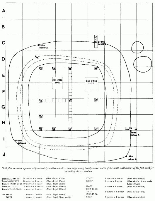
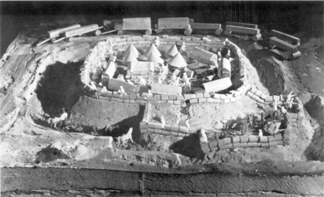
The fort is an earthwork quadrilateral immediately west of the Potchefstroom-Klerksdorp railway line and south of the Potchefstroom-Klerksdorp main road. The fort interior is approxiniately 18 metres east to west and 20 metres north to south, with bulges outwards on all sides. The external measurements are approximately 37 x 37 metres, The base of the outer slope of the earthwork varies from 1,2 to 1,5 metres below the highest point of the earthwork. The remains of an enclosure approximately 18 x 18 metres with two adjacent mounds approximately 3,5 and 5,0 metres in diameter, may be seen on the north east exterior corner of the fort, the position of the two nine pounder guns that defended the fort. No trace of the wells or rubbish pits dug during the fort occupation could be seen, except for two patches of low grass greener than their surroundings, grid refs. E3,5 F2/24-27 and 33-37 (see accompanying grid plan).

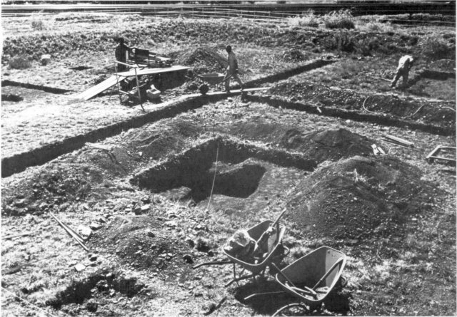
We laid out a grid in metre squares to control the excavation, approximately in a north—south direction originating 20 metres north of the north bank of the fort. Within the grid the following units were excavated in 10cm levels, all material being passed through a lcm2 sieve mesh. (See grid plan).

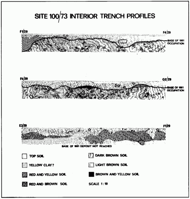
The maximum depth below PSL was reached in the two trenches C 1-2/37 and H4/45-48 excavated to determine the profile of the 1880 trench encircling the fort. The C 1-2/37 trench on the N.E. corner, revealed a fairly clear contact between undisturbed colluvial-alluvial deposit and disturbed rubble washed in after the 1880 trench had been dug. Two muzzle loader bullets lying on the contact of disturbed/undisturbed soils at a depth of 1,10 metres provided reasonable dating evidence for the base of the trench. The H4/45-48 trench on the S.E. corner revealed a similar profile, producing an 1880 helmet badge at 50cm, 4 x 10mm bullets and a thin Martini Henry cartridge at 85-l00cm on the contact of disturbed/undisturbed deposits. These two trenches provided data for the exterior trench shown in the model and the profile through the fort.
The internal structure of the fort was investigated with the system of pits and trenches shown in the grid plan. So far as I was able to determine the original interior floor of the fort dating to 1880-1881 lay on the surface of a dark brown gravelly deposit exposed at a depth of between 3cm and over 40cm in trench EO H4/29. The surface of the dark brown gravelly deposit occurred at variable depths. The post-1881 infill from the natural disintegration of the fort walls was indicated by a light brown to reddish soil overlying the dark brown gravelly deposit. The bulk of artefacts dating to the fort period or subsequent to it, occurred in the upper 50cm of deposit exposed in the trenches. Most objects were found in the light brown to reddish soil, but some did occur in the pre-fort dark brown gravelly deposit.

The two interior pits E3,5 F2,00/24-27 and E3,5F2,50/33-37 were sunk to investigate the reason for denser plant growth on their surfaces. Pit E3,5F2,00/24-27 revealed a cylindrical hole 2,l0x 1,60 metres, that contained artefacts to a depth of 70cm. A number of whole bottles, glass and other materials appeared in a white limey soil which smelt unpleasantly when first exposed. We may assume that E3,5F2,00/24—27 had functioned as a rubbish or a lavatory pit and that quicklime had been poured into it to sterilise the contents. (The limey soil was not analysed). Since no clearly post-1881 artefacts were found in Pit E3,5F2,00/24—27 we may assume that the pit was filled to surface level before March 1881.
Pit 3,5 F2,50/33—37 with a maximum diameter of 2,70m and minimum diameter of 1,80m may have remained open until after the construction of the nearby railway and introduction of .303 rifles in the 1890s. Railway tie bolts, four .303 cartridge cases, and one .303 bullet head and an almost complete dog skeleton were found down to a depth of 25cm in the pit, suggesting that the pit had remained open to receive rubbish perhaps for 20 years after the fort was abandoned. No trace of quicklime was found in the pit.
Dating of surfaces, artefacts and bones:
We may conclude that the excavation succeeded in demonstrating 1880—1881 floor surfaces inside the Fort and in two of the four external trenches and that this data provides information essential for reconstructing the Fort. Dating of objects recovered from the sieves is by no means straightforward however. The colluvial-alluvial deposit supporting the Fort has been occupied by human communities for many hundreds of thousands of years, indicated by Stone Age artefacts encountered at all levels. Artefacts which may be attributed to historic communities had been accumulating in the Potchefstroom area for forty years prior to the building of the Fort, including the fort surface which is close to the main road to Klerksdorp, dating from the 1840s. Accumulation of post-Fort materials certainly continued after 1881, as the post-Fort .303 cartridges and coal fragments indicate, especially after the construction of the nearby railway line. Post—Fort materials occur at depths of 40cm, the maximum recorded for a definitely datable post-Fort artefact (a .303 cartridge from H4/37/30-40cm).
We may expect deposits close to densely-inhabited areas such as the 1880-1881 Fort to preserve materials of all ages, although the bulk may be assigned to periods of concentrated occupation such as the December-March period of the Fort, when debris from the uninterrupted occupation of several hundred people confined in an area barely 20 metres square accumulated in the Fort and its vicinity. Part, at least, of the debris from daily life in the Fort was removed and dumped outside at night by ‘sanitary parties’ from the Fort (Bellairs 1885 p.257). Daily removal of organic waste materials during the Fort occupation may explain why we found so little bone. Mr Welbourne analysed 245 bone fragments but unfortunately the dating of all is suspect. We should also consider that the Fort’s inhabitants may have crushed every fragment of available bone for making soup.
The probability of earlier or later materials in the excavated Fort assemblages, therefore, cannot be excluded. However, quantities of artefacts such as the common Martini Henry cartridge cases may definitely be dated to the 1880-1881 period of the Fort and we may assume that a substantial proportion of the other artefacts may also be attributed to the occupation of the Fort.

The excavation and proposed reconstruction of the Potchefstroom Fort fill a wide gap in South African archaeology. There is an urgent need for archaeological investigation of sites such as the Potchefstroom Fort and the Matluassi Mission of 1823, the first historical locality in South Africa to be investigated by archaeological methods. No one can deny that objective historical education plays a critical part in the life of a complex community such as South Africa and indeed, if South Africa is to survive, the archaeology of the eighteenth, nineteenth and twentieth centuries will require development on a large scale. Substantial investment is required in publication, restoration and public facilities at sites such as Matluassi, Potchefstroom Fort, and naturally nineteenth century Iron Age sites such as Kaditshwene, visited by John Campbell in 1820 and excavated by the writer in 1966. Public facilities at archaeological sites with important historical relationships should be co-ordinated with education at all levels in South Africa. Time is short, the time to move is now.
Note: During the course of Prof Masons excavations 2 941 items were listed, sorted and identified, ranging from bits of glass and fly buttons to Martini-Henry cartridge cases and of course the inevitable bully beef tin! Ed
REFERENCES
Return to Journal Index OR Society's Home page
South African Military History Society / scribe@samilitaryhistory.org