
 The South African
Since early last year, aircraft and ships along the entire South African coastline have been able to plot their exact position in a remarkably short time with the aid of the Decca navigation system which has been installed at a cost of R6-million. The system functions day and night and requires very little dexterity from its users. The first transmitter of the system came into operation near Walvis Bay in October 1970. Similar installations have been erected in Namaqualand, the Western and Eastern Cape and Natal.
This reassuring information follows an announcement by the Minister of Defence, Mr P. W. Botha, on 22 February 1967, to the effect that a radar network of the most modern equipment had been installed to provide an early-warning system in case of aerial attack on South Africa's northern borders. Speaking at a ceremony marking the start of the academic year at Stellenbosch University, Mr Botha also said that a start had been made with the installation of a navigation system which would cover the coastline from South West Africa to Natal.
The Minister said the system would be a highly accurate, international, radio-navigational aid which would be available to all who sailed around the South African shores in times of peace. At the same time it would also be invaluable to South Africa's navy, and maritime air force, as an aid to patrols in times of war. The system would be among the most modern in the world and in wartime enemies would be denied the right to use the system.
This navigational aid is a popular system which has been installed in many countries throughout the world. Australia is planning a network around her important harbour cities. Western Europe, the North Atlantic, the Persian Gulf and parts of America, Japan and India are some of the areas served by Decca systems. South Africa's five chains are the first in the Southern Hemisphere and the installation put the country in good company.
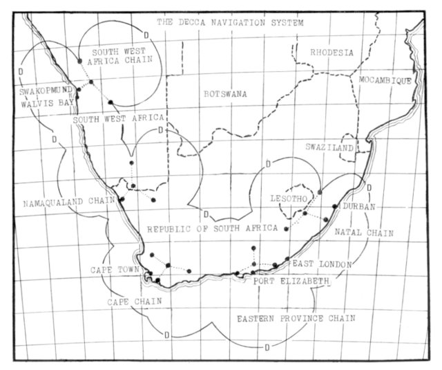
This is how the South African coastline and the adjacent interior
is covered by the Decca system.
The groups of dots connected by
dotted lines indicate the various transmitting stations.
The system - the brainchild of an American, William O'Brien - is a pre-war invention offered to the Admiralty in 1942. It was developed rapidly and put into operation during the Allied invasion of Normandy. After the war, further development was discontinued and the Decca organisation was given permission to expand the invention as a commercial undertaking which is now used by thousands of ships and aircraft annually.
Each chain of stations consists of a group of four radio transmitters - a centrally situated master station and three distant slave stations. The slave stations, which are designated red, green and purple, are usually positioned in a triangular shape around the main station and about 160 kilometres away from it. The four stations transmit constant signals in the 70-130 kilocycles band which are received as clock readings on board a ship.
When a ship fitted with the equipment enters an area covered by the system, it picks up the signals of the transmitters of the nearest chain. It is then a simple operation to plot the position of the vessel on the position grid. This can be done with an accuracy which varies according to the distance the ship is away from the transmitting stations, but which is always within a few metres.
Although the procedure for ships takes only a few seconds, it is too slow for modern aircraft. A small computer is, therefore, used to trace the flight of the aircraft on a chart, as it progresses. Pilots can plan their flights to any airfield in the area covered by the system, even if the airfields concerned are without radio aids of any kind.
Standard maps, issued by the Government Printer, are to be reprinted with the system co-ordinates.
The system has considerable advantages which are more than just a basic contribution to accuracy and safe navigation. Apart from its inherent accuracy, the most important advantage is its surface coverage. Any unit working within the effective surface - usually a radius of about 450 kilometres or more from the main transmitter - can report its position to a central place. This will enable the position of all ships, aircraft or land units to be pin-pointed accurately.
It is, therefore, an invaluable aid in search and rescue work. For anyone who must know without delay what his position is, this navigational system is the quickest, and one of the most accurate, aids available.
In addition to its aid to pinpoint navigation, it is accurate enough to he used for special activities. These include oil exploration surveys, seismic surveys, marine mining and naval operations, such as hydrographic surveying, air-sea search and rescue work, cable laying and fishing.
Navigation devices aboard ships can be used by plotters after little more than two hours of instruction. The roll, pitch or list of a ship does not affect the accuracy of the equipment on board. It should enable coastal traffic to operate with greater safety and should reduce drastically the number of strandings along the dangerous South African coastline.
A new R2-million air navigation system - the most accurate ever installed in South Africa - came into operation at the country's six major airports in 1969. Known as Vortac, the system enables pilots of light aircraft, as well as jetliners and military aircraft, to read at a glance their exact distance from airports. Vortac is a valuable safety aid, particularly in bad weather, and enables pilots to pinpoint their position from as far away as 200 miles from an airport.
The highly accurate equipment takes the form of specialised transmitters at airports. It will also assist with landings and accurate navigation in the air corridors linking airports. The installation of Vortac has put South Africa's aids to navigation in line with the most advanced countries in the world.
The Decca and Vortac systems have no link with the early warning system against air attacks, also announced by Mr Botha in 1967 and installed on South Africa's northern borders.
The early warning system consists of the most modern and sophisticated radar network which can detect hostile aircraft many miles beyond the country's borders and then guide air force interceptor fighters to the attackers. South African industries manufactured 75 per cent of the equipment in the network which is generally used by countries with advanced defence organisations. The defence of the industrial complexes and military bases in the north of the country is essential and, for this reason, it was decided to establish an air defence organisation, capable of carrying out the task.
The radar network consists of a control centre, containing electronic equipment which is linked to satellite radar stations by radio, telephone, telex and telemetric communications systems. There are stations at Ellisras, Mafeking, Mariepskop and Acornhoek, and some of them are underground, such as the one at Devon.
The station at Devon in the Eastern Transvaal is the nerve centre of the early warning air defence system. Together with the other stations, it sweeps South Africa's northern borders, from South West Africa across to Mozambique. The system was installed six months before similar NATO installations went into service in Europe.
The initial installation cost about R12-million. However, this figure will increase as the system is modified constantly to keep abreast of the latest advances in electronic warfare. Modern science continues to develop and South Africa cannot afford to lag behind. As far as is known, there is no comparable system in the world. Building work on the station commenced in February 1963 and modifications have been carried out since 1966. It is controlled by digital computers. Together with modern aircraft and anti-aircraft installations, it is a formidable deterrent to any would-be attacker.
Built underground to resist bomb attacks, the Devon station is also designed to enable personnel to live underground for a considerable time. It is air-conditioned and has all modern amenities, such as kitchens, recreation rooms and showers. It is a completely iiidependent and self-sufficient underground city with its own power sources and fire-fighting system.
All aircraft activity is controlled from the main operations room by the sector controller who is assisted by an intercept executive and a missile and anti-aircraft executive. These men are able to send aircraft into action within minutes of the computers' calculating all available information in a given situation. The computer complex of the station is said to be the biggest in the Southern Hemisphere. The computers are fed with information by the radar scanners above the ground. This information, together with data stored, is processed and sent to the operations room, indicating the best action to be taken.
The satellite stations are also equipped with computers. This makes possible complete correlation of information in the system which is also linked by radio. The system can also be used to simulate operations against imaginary enemy air attacks. It can also assess South Africa's air defence abilities in a hypothetical situation.
South Africa's long borders and the largely unguarded coastline are no longer a cause for concern. The very important ability to establish, at an early stage, the movements of any enemy brings the country's defence in line with modern warfare practice. South Africa is now ready for action in most circumstances. She had the fist with which to punch in ease of aggression; she now also has the eyes and ears to show where to punch, well in advance.
1. Radar-sambreel om kus binnekort in werking. Artikel in Tegniek.
Die Suid-Afrikaanse Nywerheidsblad. September 1970.
2. Decca Navigator Comes to South Africa. With acknowledgements to
L.S. Public Relations (Pty) Ltd. The Wheelhouse. The house magazine of the SA. Marine Corporation Ltd. January 1971.
3. The following newspapers:
(a) The Friend, Bloemfontein: 5 September 1969; 22 October 1969
(b) Die Oosterlig, Port Elizabeth: 23 Februarie 1967.
(c) The Star, Johannesburg: 22 February 1967; 13 April 1967.
(d) Dagbreek en Landstem, Johannesburg: 3 Augustus 1969.
(e) Sunday Express, Johannesburg: 3 August 1969.
Return to Journal Index OR Society's
Home page