
 The South African
In October 2016 I was contacted by Graham Taylor, Spatial Development Manager - Operations for Coega Development Corporation, to say that he had found a small building on the sand dunes near the suburb of St George's Strand and thought it might date from the Second World War (1939-1945) and might be military. Would I be willing to have a look at it with him? Of course, I agreed. I had met Graham some time before on behalf of the Historical Society of Port Elizabeth, in connection with a heritage house that CDC had acquired on a farm in their area. I called at his offices a few days later and we drove to this site in his vehicle.
The building
The flat-roofed building measures 3 m x 3.7 m internally, with a ceiling 2.4 m high. The side and rear walls are quite thick, probably about 800 mm, and the front wall facing the sea much thinner at 250 mm. The latter appears to be of brickwork, but the other three walls could be of brickwork or concrete. The front wall has an opening for a window and door frame, both now missing, with two air bricks above for ventilation.
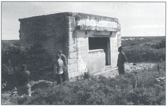
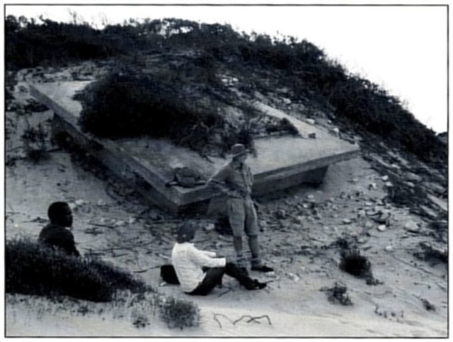
The Marker Shelter, with Graham Taylor closest to the corner of the building.
At a later date, the side and rear walls and flat roof were reinforced with a generous extra layer of concrete, being held in place on the vertical faces witl'! hessian sacks of sand, which left a characteristic pattern; this layer and the 'shuttering' are masked by two roughly-built extensions to the front wall, visible in the photograph. Graham had been told this building was a 'Ranging Station'. In front, I found concrete bases for two steel poles and another for a 70 mm square post, purpose unknown; and behind and at the sides of the building there is a wide spoil heap, perhaps resulting from the collapse of the sandbag shuttering.
When I returned home, I wrote a report on the building for Graham, but told him that I knew nothing of its history; my only thought was that its location might have made it ideal for use by air force personnel who were recording practice shots on targets towed by aircraft flying parallel with the coast. So, on a whim, I phoned my friend, Mrs Carol Victor, Africana Librarian at Main Library in the city, and told her my problem. Within a day, she had contacted me with a reference number to contact at the National Archives in Pretoria but emphasised that one had to appear in person and give a good reason for wanting the information. I passed this on to Graham but told him I was not intending to visit Pretoria soon!
In March 2017, on another visit with interested parties to his heritage farmhouse, Graham handed me an envelope with a 25 mm thick wad of A4 size photocopies and a CDC memory stick on the above subject, obtained for him by a local contact. The copies turned out to be lengthy correspondence relating to the setting up of these ranges. I sorted the letters into date order and then read through them to obtain the story.
The correspondence from National Archives
Lease of land at Parson's Vlei
Parson's Vlei is an area to the west of Port Elizabeth, to the north of the present-day suburbs of Morningside and Bridgemead; it is still open grazing land to this day. The documents started with a letter dated 11 January 1941, from the Secretary for Defence to the Rev (Samuel N) Hyde Smith, Vice Provost and Rector of the Collegiate Church of St Mary the Virgin, Port Elizabeth (now the Anglican Cathedral of St Mary), concerning permission for the lease of church land at Parson's Vlei for use as a bombing range. On 7 February the Secretary wrote that the Government had found that it would be necessary to rent only one of the two parts of this site. On 11 February, Rev Hyde Smith confirmed agreement to this proposal; the Secretary emphasised that the range would be used for low-level practice bombing using 'cement bombs, so that there will be no burst or blast effect.'
Accommodation and sanitary services for personnel to man the ranges
From 8 May until 26 August 1941, the correspondence dealt almost exclusively with the subject of 'Accommodation and sanitary services for men at the bombing ranges (Swartkops and St George's Strand)', with two further letters on 13 and 27 November in the same year.
Weekly expenditure returns
It also included covering letters for these returns between 16 May and 22 December 1941 but, as no monetary amounts were shown, they were of limited interest and not relevant to this study.
Development of the ranges
From 17 January 1941 there was almost continuous correspondence on the development of the ranges; most of this was between the Secretary for Defence and the Public Works Department, as well as interaction with the appointed contractor, Thomas M Hill & Company of Port Elizabeth. Much of the information comprised specifications for the work in which reference was made to various detail drawings. Unfortunately, these drawings were not included in the information received from National Archives, so I have only summarised the content where relevant.
In the letter of 17 January, mention was made in the heading and the text to 'Bombing and Air Gunnery Ranges, St George's Strand, Cape Receife and Parsons Vlei'. The letter went on to state that '[a]s the bombing targets for the St George's Strand and Cape Receife ranges are sea targets, the Harbour Engineer at Port Elizabeth has been consulted in regard to the construction and mooring of these, and the SA Railways and Harbours Administration has agreed to their construction by the Harbour Engineer.'
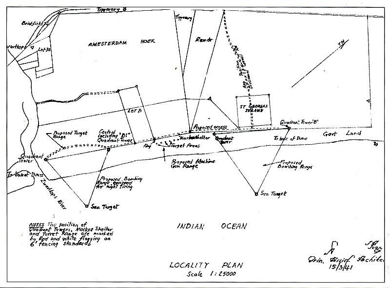
LOCALITY PLAN
The decision to develop a bombing and air gunnery range off Cape Receife was countermanded by a letter dated 12 March 1941, stating that it 'has been abandoned', and it was not mentioned again in the correspondence. The letter of 17 January 1941, from Headquarters, Union Defence Forces to the Secretary for Public Works, gave some quite specific instructions for the construction of targets:
'At the Parson's Vlei Range, the bombing target is to consist of a pyramid with a triangular base, each side being 8 ft long, and [the pyramid] 4 ft high, built up of stones present on the site selected. The stones are to be graded, securely bedded and bonded to form a stable and satisfactory piece of work. The cairn is to be white washed and chequered yellow and black. The pyramid of stone is to form the centre of a circle 25 yards inner radius 4 ft wide, formed of light coloured and/or white-washed stones worked into the ground. Two 4 ft wide lines, of similar construction, are to intersect the centre and run respectively magnetic north-south and east-west.'
The letter gave financial authority and requested that 'this work be put in hand as soon as possible.'
A further letter, dated 12 March 1941, from Secretary for Defence to Secretary for Public Works stated: '[t]his is to be a low-level bombing range and both Quadrant Towers need only be 2 storey structures' and 'the bombing target to be constructed ... should be as specified in paragraph 5 of my minute dated 17th January 1941' [as already described above]. I presume that this range was constructed, but have walked on several occasions in this Parson's Vlei area and was not aware of this part of its history, so reinstatement of the land appears to have been very thorough.
At the bombing range east of St George's Strand Township, 'the positions of the Quadrant Towers have been marked on the ground by red flagging on 6 ft fencing standards. In each case the Tower must be so sited that the point of the Quadrant bench on which the Quadrant sight is placed will correspond to the fencing standard marking the position of the Tower.' The description was similar for the 'Bombing Range near Zwartkops River'; again, there were no detailed drawings included, just the 'Locality Plan' described below. In both these locations and at Parson's Vlei, it was stated that 'Lavatory accommodation is required for both sexes at each Quadrant Tower.'
The Locality Plan
Together with these photocopies of correspondence, the envelope contained copies of two blueprints, one of which was a 'Locality Plan' to a scale of 1 :25 000 of the coastal area from the Zwartkops River for about 6.5 km north-eastwards and inland as far as the Wylde Bridge on the (old) road to Grahamstown. This plan reveals quite a deal of information on the proposed layout of the ranges in this area. As these blueprints were only photocopies and rather indistinct, I took the trouble to borrow a light table from a friend, so that I could make a tracing of the Locality Plan. Although not perfect, it was sufficiently improved to enable me to see details that I previously had not noticed on the photocopy (see attached Locality Plan, p124).
The titles of Zwartkops River, Amsterdam Hoek and St George's Strand were used for these bombing ranges in the correspondence, without specifying which name applied to which range. According to their location on the plan, as only two bombing ranges were marked in this area, I have assumed that the first two names apply to the western range (close to the later suburb of Bluewater Bay) and the third to the eastern range near St George's Strand suburb. The western range was qualified on the Locality Plan with the title 'Proposed Bombing Range equipped for night firing'.
The Locality Plan shows two equilateral triangles, with sides of about 1 250 metres in length, marking the positions of the two 'Proposed Bombing Ranges', one just north-east of the river mouth and the other a further 3 250 metres (or 3.25 km), centre to centre, up the coast to the north-east. In both instances, the base of the triangle was positioned at the back of the beach, with the third corner (the 'sea target') in the water. Both triangles were also to have a Quadrant Tower at the two landward angles: the North-East Tower of the east triangle titled 'Quadrant Tower "B'" and that of the west triangle, 'Control including "B1" Quadrant Tower'. In the letter dated 12 March 1941, reference was made to a PWD (Public Works Department) Drawing Number for each Quadrant Tower, but, once more, we do not have these drawings, so have no idea what the towers looked like or of what materials they were constructed.
However, Clause 5 (b) of the letter stated, with regard to the Zwartkops River Range, that '[t]he ground floor, instead of being reserved for a Battery Charging Room, will be used as a telephone exchange at which all telephones from the other Quadrant Towers and from the markers' shelter converge, and from which the main telephone to the Air Station is laid. An extra window should be provided in this ground floor room.'
The arrangements for lighting this Zwartkops River Bombing Range are of special interest. Clause 5 (c) of the March letter reads: 'No drawings of such a signal exist in the country, but two alternatives seem feasible: (i) A row of electric bulbs fitted down the centre line of the shaft and barbs of the arrow; the centre of circuit strips; and single lights in the centre of each of the three signalling balls will provide sufficient illumination to be visible from any height. The great difficulty of this method is to design a signal that will permit of its normal use during the day without interfering with the lighting fittings. (ii) The second method is to outline the signals in electric bulbs, which are protected by the walls of a galvanised iron trough. This scheme would be more effective than (i), but this again is off-set by the greater expense it will involve. It is not known whether electric power is available within reasonable distance of this range, and the fact must be faced that if other bombing ranges which are under consideration are required for night bombing, some will almost certainly be remote from electric power supply. The question of providing a small petrol-electric lighting set for this purpose or floodlighting the bombing signals by means of acetylene flares seems worthy of consideration, and I should be glad to have your views on this matter.'
I have two comments regarding this description. Firstly, I would love to know what the contractor made of these electrical arrangements. Secondly, it is worth noting that, by 1942, the problem of keeping electric power available 24/7 at remote sites had been solved; sites for coastal radar stations were being set up for the Special Signals Services (SSS) and, as the radar set had to be operational and manned continuously, diesel generators were provided at all sites and apparently gave no trouble. In researching this subject some years ago, I found engine rooms still present at four of the remote sites out of the total of six radar stations built in the Algoa Bay area, but probably all six stations were so equipped.
Half-way between the two proposed bombing ranges on the Locality Plan there is an arrow pointing to 'Proposed Machine Gun Range'1, marked by a series of dots along the back of the beach, which, in turn, are titled 'Target Areas'. To the east of the dots a 'marker shelter' is indicated on the upper part of the beach between the two bombing ranges, but on the St George's Strand side, almost exactly where the building described at the beginning of this article is situated. So now we know the official title for this small building.
The Locality Plan was signed in the bottom right corner by what appears to be 'J A Jean', who used the title 'Prin. Assist. Architect' [Principal Assistant Architect], and the plan was dated '15/3/41 '. It also carried, just above the title, a rather florid monogram, which may be that of the principal architect, confirming that he had checked and approved the plan. [Note: The error of spelling the name 'Amsterdam Hoek' as 'Amesterdam' is the draughtsman's, not mine!]
The second blueprint
The second drawing was titled 'Layout and details of bombing & air to ground range' ('Drawing No 10459/2'), to a scale of 1 inch to 100 feet [1: 1 200]. This appears to be a detailed drawing of the machine gun range between the two bombing ranges at Swartkops River and St George's Strand, and may be the 'Amsterdam Hoek Range' referred to in the correspondence. I have not studied this drawing, as the site is now covered by the suburb of Bluewater Bay.
I happened to mention this correspondence and the drawings to Paul Stringer2 of the South African Air Force Museum in Port Elizabeth for his comments. He wrote: 'Apparently Parson's Vlei was used as a low-level bombing range, whilst those of Swartkops, Amsterdam Hoek and St George's Strand were used for high-level drops. They had a raft anchored off the coastline and the pupils dropped practice bombs made of concrete from 10 000 feet in an effort to hit the raft. I guess the staff headquartered at these ranges were there to measure how close the bombs got to the raft. (I don't know how they would have measured accuracy, unless they had circles of roped pontoons around the target raft).'
The construction contract
The contract for the development of the three bombing ranges at St George's Strand, Swartkops/Zwartkops River and Parson's Vlei and the machine gun range at Zwartkops was officially awarded on 7 May 1941 to Thomas M Hill and Company of Port Elizabeth. A later letter mentions that the sites were handed over on 15 April 1941, the actual completion date being 15 September 1941, and the PWD Completion Report being dated as late as 27 April 1944. Because of the urgency of the construction, the work did not go out to tender as per the customary practice.
Much of the correspondence was between the contractor and officials of the PWD, including their Chief Quantity Surveyor (CQS). On 29 October 1941, the contractor wrote to the District Representative PWD regarding the final account for the bombing ranges that they 'are entitled to recompense for use and waste of shuttering for concrete work ... used in the construction of the Marker Shelter and [for] the foundations of the various towers; about 1 500 feet of second-hand flooring was used for forming various gangways on the sand to allow [for the] barrowing [of] materials.'
The letter continued: 'Owing to these gangways having to be moved from point to point and ... cut up with the wheels of the barrows, these boards were useless on the completion of the work.' It also stated that '[owing] to the fact that no water was available on any of the various sites, as claimed in Clause No 29, page 14 of the conditions of contract, we were forced to purchase containers to transport and store drinking water for the workmen employed on the numerous and widely distributed sites. To ensure sufficient drinking water at the various points, we were forced to purchase six 5-gallon milk cans at a cost of Ł10. 1. 0, as shown on attached invoice, of which we have five on hand' (the cash invoice dated 23 April 1941 for this purchase was amongst the papers.) The '5 cans on hand' is explained by a paragraph stating that they advertised in the public press and, following inspection by some farmers, found that 'we are unable to dispose of them as they have become useless for dairy purposes owing to the rust spots due to storage of water in them.' This letter and receipt were forwarded to the District Representative Public Works Department [DR PWD], who recommended to the Secretary PWD that the contractor be compensated for the cans and for the flooring at 2d per foot. [Incidentally, the contractor did not mention also that water was not available on site for mixing concrete.]
On 15 November 1941 the CQS of PWD stated that he 'visited the three sites & can vouch for the fact that Contr [Contractor] had a tremendous task'. On 24 November 1941, Thomas Hill wrote again to the DR PWD complaining that it was nearly three months since completion of the service but they had still not 'received the final account and adjustment of retention money being held.' They were notified on 17 January 1942 that PWD 'will accept liability up to Ł5 for the use of the drinking water containers and will make an allowance of 2d per foot for the timber gangways used on approaches.'
Thomas Hill was still writing on 30 March, 2 June and 9 July 1942 for the Final Statement and Final Payment. On 4 August 1942, he was complaining that an offer of Ł60 against a claim of Ł100 in retention was still unsatisfactory. He commented 'that owing to the distances between the various sites, the absence of roads and the delay in obtaining information, this work has not been profitable to us, and we might state it was the most unsatisfactory and unpleasant work which we have been called upon to carry out during the period of nearly thirty years of our business career'. He insisted on 'the Terms and Conditions of the contract being carried out without further delay.'
On 21 October 1943, McWilliams and Elliott, Solicitors & Notaries, wrote to the Secretary for PWD demanding settlement of the balance of Ł113.12.11 due to Thos M Hill and Company on this contract and threatening legal redress if payment was not received within 10 days.
On 28 October 1943, the Secretary PWD gave the reason for delay in settlement of account as: 'The control of this expenditure [war work done by this Department exceeded Ł10 000 000 and, of this huge sum, Ł9 840 000 has been paid out to contractors] has had, owing to the exigencies of war, to be carried out by a very depleted staff and, although the Department has advertised on several occasions throughout the length and breadth of the Union, it has been unable to secure the services of additional Quantity Surveyors [presumably because many of them were on active service.] The result is that the Department is doing its best to assist contractors but it cannot do the impossible.' McWilliams & Elliott replied on 13 November that the PWD letter has been considered by their client 'in conjunction with the Port Elizabeth Master Builders' Association ... and we are instructed to enquire of you, before taking legal action, as to the date when you will be in a position to settle our client's account.' The Secretary PWD replied that every endeavour would be made to bring the service to finality before the end of December 1943.'
The PWD Completion Report is dated 27/4/44 and the 'Completed Cost' recorded as Ł5 764 a 10. A letter dated 26 June 1944 from Secretary PWD to Secretary for Defence gives a list of extra works on this contract, which included '6 three istorey in lieu of 3 two storey and 3 three storey towers, addition of a Generator House [for the target lights?], notice boards, retaining wall to sand dunes, increased foundations and reinforcements, etc.' The date of final settlement to the contractor and the amount paid are not recorded in the correspondence.
By 18 December 1945 (ie, seven months after the end of the Second World War in the European theatre on 8 May), the Colonel Commanding EP Command was querying whether the necessity of continuing to rent some ten military sites around the Eastern Province was 'fruitless expenditure'. The correspondence on this subject ran on until 18 February 1946.
What remains on site at the St George's Strand Bombing Range?
In November 2017, Graham Taylor arranged for several interested parties to meet at CDC Offices to be taken out to the sites of the two Quadrant Towers of the St George's Strand bombing range. The wind was pumping strongly and whipping up the dry sand, so that the inspection was quite unpleasant and it was impossible to take measurements and construction details in those conditions. Having, in the meantime, studied the correspondence from the National Archives, I could imagine what a task this turned out to be for the poor contractor. Access to the beach alone was a mission, with a steep climb up onto the dunes from the parking area, so I don't know how the contractor coped with barrowing materials and water onto the site.
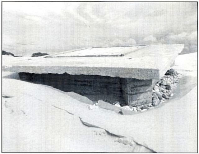
The base of Quadrant Tower 'B'.
We assembled again in April 2018 and walked to the base of the North-East Quadrant Tower. This time the wind was again quite strong, but I managed to take
measurements and GPS coordinates as follows:
Base of the North-East Quadrant Tower 'B': This base now sits on the surface of the sand and the slab measures overall 5.83 m square and about 220 mm
thick (variable). It has a rectangular foundation set in 600 mm from the edges of the slab, with 'wings' projecting a further 410 mm out by 610 mm wide n~ar the top edge
of the base; the bottom (seaward) corners of the foundation have 'wings' of similar size projecting diagonally from the main rectangular foundation (see photo on p 127).
All foundations are 900 mm deep; the thickness will not be known without excavating under the slab. At present this "base is tilted at an angle of about 100 to the
horizontal.
On the top surface of the slab is an upstand or kerb, 100 mm wide by 60 mm high, forming an inner square; I believe that this square retained the base of the tower, which was probably of timber and weather-boarded. At the four corners of this kerb, there is a shallow recess 155 by 160 mm in size, which was probably designed to secure the corner timbers of the tower; and scattered over the top surface is a series of seven smaller recesses. In the centre of the square formed by kerbs, a large white cross has been painted, but this is not an original feature.
The slab and foundations of the base appear throughout to be of reinforced concrete, as one would expect on such a soft and moveable dune sand site, and seem to have been cast as one integral unit; I believe this method of construction accounts for the good condition of the base after 77 years in situ and exposed to the winds of Algoa Bay. I took GPS readings with my hand-held Garmin eTrex Personal Navigator at the top edge of the base; the co-ordinates are S33° 49.24' E25° 39.82', and the height above sea level, four metres.
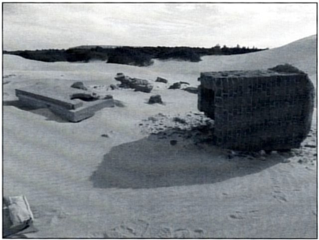
Lavatory remains: We are fortunate to have also on this site the remains of one of the two lavatories specified to be provided for each Quadrant Tower. This comprises the concrete floor slab of one cubicle, with the opening for the lavatory fitting and its foundation and, nearby, the square shaft (which fitted below the opening) in 223 mm thick brickwork with the concrete foundation still adhering to one end. The shaft measures 1.25 m square externally and is now 1.5 m long. These items, together with a quantity of brickwork rubble, are on the surface of the dune about 100 m back from the base of Quadrant Tower B'.
Base of the North-West Quadrant Tower: We then returned to the vehicles and were transferred to the second site. This tower base is also quite complete but, by contrast, is now reclining at an angle of about 30degrees to the horizontal, against a steep west-facing dune. The overall measurements and features are similar to those of the North-East Tower base, though the detail in the centre of the slab is obscured by a large bush growing on the concrete. The one feature which I found interesting is that two stumps of rectangular timbers, about 150 mm long, are visible protruding from the holes in the slab in diagonal lines between the bottom corners of the slab and the corresponding corners of the kerb. These timbers are fixed at a raking angle to the surface of the slab and may have been struts supporting these angles of the tower. In other respects, this base appears similar in size and detail to its North-Eastern mate.
The base and shaft of one lavatory near Quadrant Tower 'B'.
The base of North-West Quadrant Tower, St George's Strand bombing range.
I took GPS co-ordinates at the foot of the base as follows: S33° 49.97' E25° 39.20'. Height above sea level: Eight metres.
Author's Notes
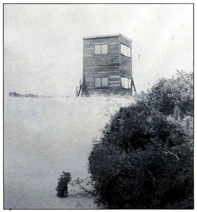
This is almost certainly Quadrant Tower 'B' at St George's Strand,
photograph taken by Corporal Cecil Jones, Royal Air Force, in 1943.
(Photo: By courtesy, Michael Jones).
Acknowledgements
I am especially grateful to Graham Taylor and CDC for permitting me and other interested parties access to these historic sites for this research; and for arranging copies of the contemporary correspondence to be obtained from the National Archives.
Mrs Carol Victor, Africana Librarian at the Main Library in Port Elizabeth, was instrumental in finding the key to the archival correspondence, without which the history of these ranges would not have been revealed.
As mentioned in Author's Note 1 above, Dave Thompson's recovery of the cartridge case and Richard Henry's expertise on this ammunition have given an indication of the weaponry used in 42 Air School's practice shoots at the coastal machine-gun ranges.
Because of the local history interest in Port Elizabeth, the author has arranged for the article to be published also in Looking Back, the Journal of the
Historical Society of Port Elizabeth.
Return to Journal Index OR Society's Home page
South African Military History Society / scribe@samilitaryhistory.org