
 The South African
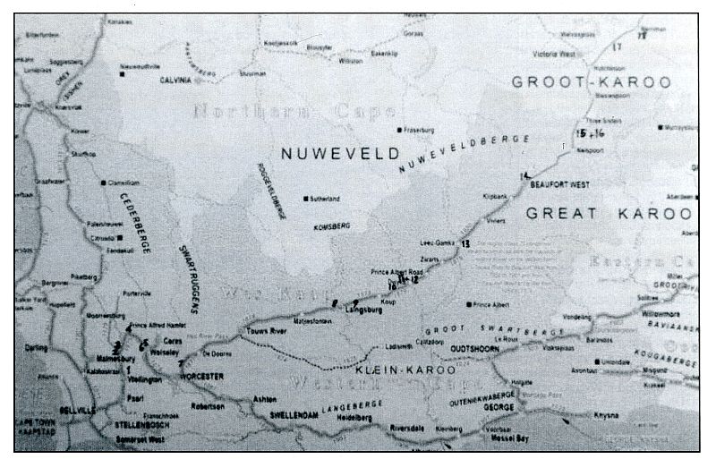
A map of the railway route from Cape Town to De Aar,
showing the blockhouses numbered as per list.
After the Second Anglo-Boer War (1899-1902), Colonel S Waller, Royal Engineers, compiled A History of Royal Engineers Operations in South Africa 1899-1902. In Chapter XIV (pp 3-5 of this document), he states: 'In Cape Colony in the early part of 1901 the De Aar Railway was blockhoused with masonry blockhouses from Wellington (45 miles [72.4 km] from Cape Town) to Richmond Road [Merriman] 454 miles [730.6 km] distant. In this distance there were [eighteen] blockhouses placed for the defence of the large railway bridges; they were elaborate structures of stone or concrete and were erected by contract, [three] contractors being employed.'
In discussing the contribution of Australian-born South Africans in his book, Sisters of the South (1951), Conrad Lighton identifies one of these contractors (p248): There was Mr Alfred George Gray, the Cape Town builder, who probably had more memorials standing to his activities than any other man in South Africa. He built the blockhouses which have stood at many of our railway bridges and other strategic points for the past 50 years. Mr Gray passed away at a ripe age in February, 1951.'
In his History, Colonel Waller continues by describing the construction of the blockhouses:
'Choice of sites. The position of the bridges rendered the choice of sites a difficult one. The rivers had, as a rule, low banks liable to flood during heavy rains and generally composed of alluvial deposit, a fine, spongy silt unsuited for the foundations of a heavy building.'
The bridges, on account of this formation, were generally approached by heavy embankments, which produce dead ground and restrict the fire of works placed close to them, so that the difficulty lay in getting the necessary command and yet keeping near the bridge.'
'By increasing the width of footings, suitable sites were in some instances obtained with a good field of fire through the bays of the bridge between piers, in which case one blockhouse sufficed, as at Richmond [Richmond Road, now Merriman]. With long bridges, a second blockhouse was necessary to ensure covering the dead ground caused by the embankment at the far side of the river; a small work to hold [seven] or [eight] men, placed at the diagonal corner, was generally found sufficient for this purpose. In the case of two bridges close together, as at Brede River and Dwyka, one blockhouse at each bridge has sufficient, as they could co-operate.'
'Contract time. The time stipulated in the contracts for the completion of the blockhouses was six weeks, which, even under favourable conditions, was too short a time. It turned out, owing to delays in railway transport, incorrect delivery of material (some of which, owing to pressure on the railways, was entirely lost), insufficiency of labour and other causes, that the time of completion ranged from [three] months 24 days in the case of the blockhouse at Tweefontein [now De Wet] to [five] months 11 days in that of the Western blockhouse at the Breede River [Wolseley].'
Construction materials
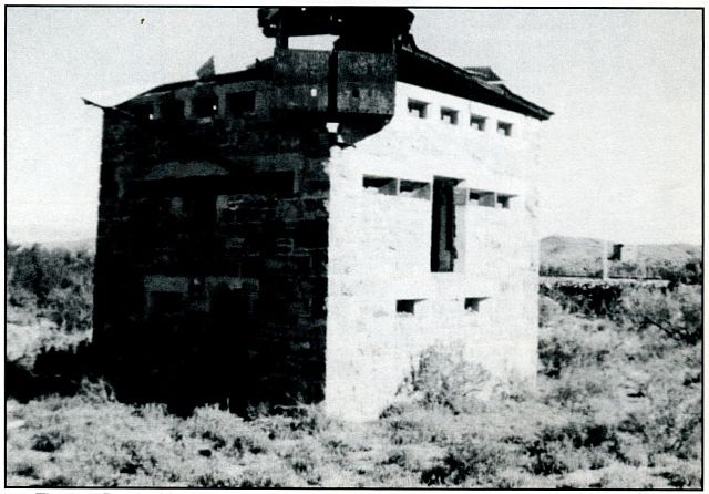
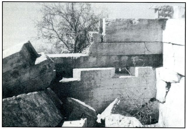
Here I would like to add my brief comments on the materials used for constructing the walls of this run of blockhouses. The rule, in general, was that, wherever sound building stone was available in the locality, this was to be quarried and delivered to the site. Cement and sand was to be used for mortaring and pointing the stones. However, it was decided in five cases - at De Wet, Laingsburg (Geelbeck River), Krom River South (Krom River), Krom River North (Salt River) and Merriman - to utilize shuttered concrete, without steel reinforcement, for the walls.
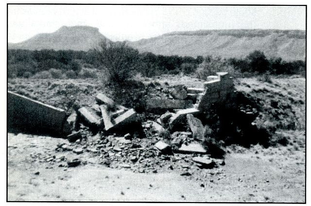
The two blockhouses at De Wet and Krom River North have collapsed. They were built too close to a river or watercourse. Nevertheless, this experiment must be deemed successful as the other three examples are standing in good condition to this day.
I have not encountered evidence of any further examples of concrete-walled blockhouses around the country. The reason for the discontinuance can probably be explained by the expense of the materials (especially the imported cement) and perhaps also the cost of labour and material in the use of wood plank shuttering.
In search of blockhouses
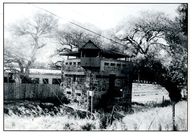
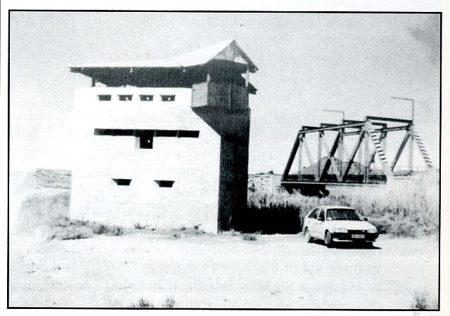
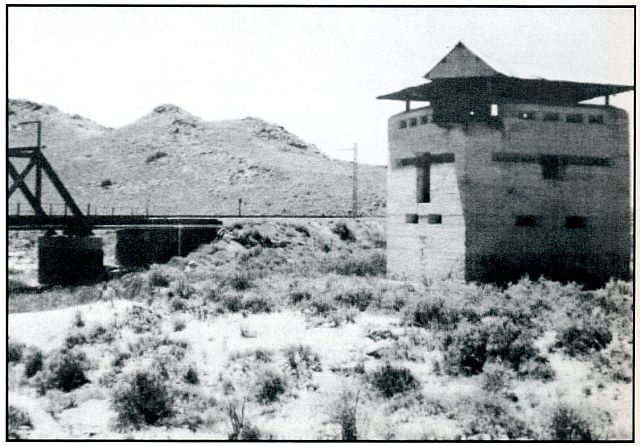
In 'Britain's Last Castles: Masonry Blockhouses of the South African War, 1899-1902' (published in Military History Journal, Volume 10 No 6, December 1997), I gave these three-storeyed masonry blockhouses the term 'Standard Pattern', as they were built to the original design of Major-General Sir Elliott Wood, KCB, Engineer-in-Chief, South Africa (1844-1931) and the design was used, sometimes with small variations, in other parts of the country.
In the mid-1990s, the locations of a very few of this run of eighteen blockhouses along the Cape Town-De Aar line were common knowledge. The two at Wellington and near Laingsburg (Geelbek River) are much photographed and both are mentioned in The Historical Monuments of South Africa by J J Oberholster (The Rembrandt van Rijn Foundation for Culture, at the request of the National Monuments Council, 1972) and countless other publications.
In 1996 I decided to try to locate the remaining sixteen, in conjunction with a tour of Anglo-Boer War fortifications extending from Stormberg and Aliwal North in the Eastern Cape to Wellington in the west. I reasoned that, if these blockhouses were still in existence, I should be able to find them by following the railway line as closely as possible from Merriman, using the railway service roads. This search was fairly successful as I found all but two. Much of my success was due to the valuable guidance I received at Beaufort West from Mrs Rose Willis, at that time in charge of the Tourism Office in the town, who had made a study of these blockhouses and written a short typescript summary for tourists. In 2004 and 2009 respectively, I located the sites of the last two.
It should also be mentioned that some corrugated iron blockhouses, fences with occasional gates and small one-storey forts were erected at the same time to defend individual features or vulnerable sections of the line between these Standard Patterns. I duly noted remains of those forts still surviving on my 1996 tour, but, as these structures were made of unmortared stone and fragmentary in condition, they are not included in this account.
Location and condition
During my search, I recorded the locations and condition of the blockhouses in this important line for the benefit of fortification enthusiasts and members of the public who might find this interesting:
Starting at Wellington, the complete list of eighteen Standard Patterns in this line (with the generally used name for each structure in italics, its former place name as used in the war-time records, given in square brackets, and the associated river, in round brackets ):
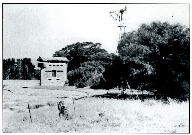
Wolseley South-Eastern Blockhouse
(Photo: R Tomlinson)
Author's note:
It should be borne in mind that I recorded most of these blockhouses in 1996, Tulbagh Road and the two at Dwyka in 2004, the site at Laingsburg Bridge, the pair at Wolseley and the Beaufort West one revisited in 2009. Although I have revisited some of the easily accessible examples later when passing, my comments on the condition of these structures essentially date from these years. These masonry blockhouses are one of the more eye-catching reminders of this period of South Africa's history.
Return to Journal Index OR Society's Home page
South African Military History Society / scribe@samilitaryhistory.org