


For the first time in many years, we had a double feature at our meeting on 11 October 2016. Our first speaker was Ms Barbara Castle whose topic was research in archives, looking for information for a new book currently being researched. She and Mr. Ian van Oordt, our second speaker, spent two months in Europe and visited 15 archive repositories in 4 countries in a period of 8 weeks. This was the culmination of a long period of research for Mr van Oordt's forthcoming book on the Battle of Blaauwberg.
Much research had been done locally. Many documents had been sighted locally, both originals or copies of others held overseas and many books and other printed documents had been read locally but our speakers felt it was important that they look at the originals of the overseas records referred to in the books consulted, as sometimes only part of a document was referred to or the writer gave an interpretation of the contents of a document.
Very often, it is easy to get side-tracked when looking at original documents so the boundaries of the research to be undertaken had to be carefully defined - what should be included in the book, what was useful as background information and what was just interesting to know had to be decided up front. Many of the repositories have on-line indexes and search engines which enabled our speakers to decide where to go and how long to spend at each place. Their research started long before their trip and eventually they selected over 1,000 documents for viewing, divided up into priority groups and by repository.
Original documentation is held in a variety of repositories, including archives, libraries, universities, museums, public collections and private collections. Each has its own rules for access and behaviour on site. To gain access you need at least two forms of identification, complete forms and agree to abide by the rules. Some larger places will give you an access card.
Access to the records is usually free but some charge a photographic or copy fee. Standard to all of these places is that you leave all outdoor clothing and bags in a locker and you may only take in a clear plastic bag with paper, a pencil and your notes. No erasers, pens, pencil sharpeners and NO sharp objects are allowed and NO food or drink. These rules are strictly enforced.
The smallest repository visited had space for two researchers and the custodian. The largest one accommodated over 900 researchers and a large staff. The big places use computer access for searching and requesting documents and the method of delivery also varies from place to place.
Handling documents that were written hundreds of years ago is an amazing feeling, almost like looking into a different life through a paper window. It is a privilege to be allowed to handle these documents. Researchers are under surveillance at all times either by staff or cameras. Correct treatment of documents is paramount. Any abuse or bad behaviour and a staff member will be right on to you. They are firm and will show you the correct way to deal with the documents. Most repositories are climate-controlled and it can be tiring working in an atmosphere suited to preserving documents. Some areas have reduced oxygen levels, most are dry and dust-free. Frequent trips to the nearest coffee machine are necessary, both to keep mobile and keep up fluid levels.
Our speakers were allowed to photograph most of the documents viewed. This proved to be a quite complicated process, as illustrated in the presentation. The exceptions were a book still under copyright and documents from a private collection. Using information from the documents is allowed with acknowledgement, but reproducing any part of a document requires permission.
The bulk of the documents viewed were hand-written. Some people had clear legible handwriting and others were elaborate, stylish and therefore hard to read. The condition of the paper also varied - some ink had faded, the paper might have deteriorated, or there were traces of water and fire damage on some of the documents. Our speaker showed us photographs of various documents to illustrate this. The trip was definitely a working trip with little time left for sight-seeing. Most repositories are open for 7 - 8 hours daily with one late day, which could result in a 10- hour working day. Each evening our speakers checked that the photographs were clear and legible, researched any additional topics found and planned for the next day. One could use the services of professional researchers but this could prove to be restricting as many of the documents found by our speakers led to new documents or different leads to follow up.
Our speakers visited Holland, Scotland, England and Belgium and came home with over 25,000 photographs of documents, which will take some time to work through.
Our second speaker was Mr Ian van Oordt who spoke about their visit to the battlefield of Waterloo, one of the most important battles ever fought in modern history which took place just over 200 years ago.
The idea to visit the battlefield began early this year when our speakers decided to visit Europe to do research on the Battle of Blaauwberg. The range of the cannon used was central to defining the position of the Batavian line at Blaauwberg. Although range tables are available for the guns in use in 1806, these cannot define how far apart the lines were or depict the terrain on a particular battlefield. A visit to Waterloo would provide an opportunity to do this and the battlefield was within striking distance from The Hague.
The battlefield today is in more or less the same condition as it was 200 years ago. There have been a few new developments and some of the forests which were damaged during the battle have since been cleared to make way for agriculture. For a battle of such importance, the area in which it was fought encompasses no more than five km by five km (25 km2). With the exception of La Haie Sainte, most of the farmhouses still exist, more or less unchanged on the outside. Some have been turned into museums and others are farmhouses, now privately-owned. Some of the owners are not overly friendly and ringing the doorbell of these private residences could result in you possibly coming face-to-face with a shotgun.
Our speaker's tour of Waterloo battlefield took place on the 201st anniversary of the battle. The weather was very similar - early rain in the morning and remaining overcast for the rest of the day. Not ideal for photography but perfect for expe-riencing the battlefield. Accounts of the battle refer to the depth of the mud. These accounts, according to him, were accurate.
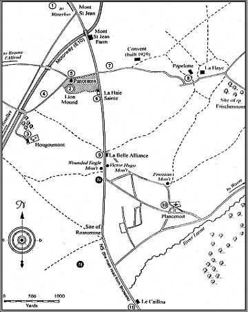
The tour started off at Picton's Memorial (7). The British and Allied line stretched to west and east of this along the Ohain Road (5)-(7). You are standing on the summit of a hill. Behind you, the ground at first slopes away rapidly and then more gently. Looking south towards the French line, the ground gently slopes away and appears almost flat. This is an illusion. It was up this slope that the French infantry under D'Erlon attacked the Allied line. The position is a typical Wellington position - on a hill, with space for the troops to shelter behind the crest and avoid artillery and musket fire until the order was given to mount to the top of the hill and launch volleys of musket fire almost at leisure at the enemy now near at hand. One can conjure up the feelings of the Allied troops as the French columns advance up the hill.
The next destination was southwards, towards the Farm of La Haie Saint (6), 200 metres away and enclosed by high walls and the backs of a number of buildings or barns. It is in a sorry state and is in dire need of repair.
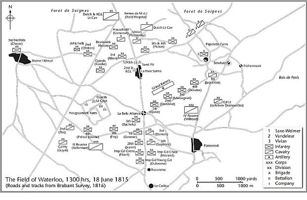
Our speaker then walked eastwards from the Brussels-Gennape road a few metres into the field and made his way back up. The slope is gentle at first but becomes considerably steeper near the top. Within metres of starting, his shoes felt like lead weights, walking becomes very difficult and one soon realises how difficult it must have been for the French troops. The soil is a rich black/red loam which binds easily and sticks like glue to one's shoes. That slight slope suddenly becomes a major obstacle. The Ohain road runs west to east and marks the position of the Allied line (4)-(5)-(7). Today it is only about one to one and a half metres below its original height , the top soil having been removed to construct the Lion Mound (2). Gone is the hedge-lined sunken road, a key feature of the eastern part of the battlefield. 600 metres east of Picton's Memorial is a modern convent. Here the road forks. The left fork is part of the old Ohain road. The new right fork takes one down to Papelotte farm (8), 850 metres further east. It is now a riding school. This was the extreme eastern flank of the battlefield. Moving further east from Papelotte, the road forks again. This is the site of the farm La Haye, now a ruin. Here one can get an idea of the sunken road, the sides of which are steep and slippery and about 3.5 metres deep. A serious obstacle.
Moving back west towards Papelotte, the road forks. The right fork takes one along the position of the French line. This is near to where many of Lord Uxbridge's cavalry met their fate. Returning to La Haye and Papelotte, our speaker took the right fork to Fischermont and turned southward there. About a kilometre down this road there is a junction. Taking the right turn westwards, one is on the route taken by Bülow's Prussians. Some 600 metres further one reaches a summit which is where the Prussians first had a glimpse of the battle. The battlefield is spread out some two km away to the north-west. Going further along this road you come to Plancenoit Church (10), where the Prussians attacked the French under Gen Lobau. Just before you reach Plancenoit, one finds the Prussian Memorial and the burial spot where 6,000 Prussian dead are buried in a plot 40 metres by 40 metres. A short way from there the road forks again - left back to Plancenoit and right back to the battlefield.
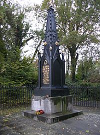
Prussian Memorial
The visitor who takes the right fork will come after about 1.2 km to a small hill on his left. This is the highest spot on the battlefield and was used by Napoleon as an observation point. The whole battlefield can be seen from here. The Genappe road and the French line are just in front of this. At the intersection of this road is the farm La Belle Alliance (9), used by the French as their hospital.
At the Genappe road intersection our speaker turned south and, 200 metres later, on the right is the Fallen Eagle Monument (9), at the place where the Old Guard waited for the order march to battle. Continuing southwards, the traveller reaches the farm Caillou, Napoleon's headquarters which today is an interesting museum depicting the French side of the battle. Back-tracking northwards on the Genappe Road past La Haie Sainte to the intersection of the Ohain Road, a left turn brings one to the western flank of the Allied Army.
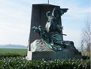
Fallen Eagle Monument
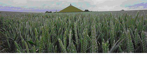
The Lion Mound, 42.5m high and completed in 1826.
The outer wall of Hougoumont's orchard is clearly visible. The traveller is now standing on the ground held by Wellington's infantry squares. Finally one reaches Hougoumont Farm (3) & (BELOW) which was the western flank of the Allied army, of which the Chateau and many outbuildings were entirely burnt down during the battle and not rebuilt. The whole outcome of the battle hinged on the retention of this position. There is a small museum there. Points of interest was the killing field, a 40 metre-long open patch of ground extending from the farm buildings to an extensive forest to the south-east. Only three dead trees remain. Inside the compound is the half-destroyed church and two monuments one for the British defenders and the other to the French attackers.

View of the Main Battlefield from the Lion Mound
The entire talk was illustrated with many excellent slides of the various points of interest discussed above. Why did Wellington chose the field of Waterloo for his battle against Napoleon? Wellington's initial choice was the area finally occupied by the French - the La Belle Alliance Ridge. His Acting Quartermaster General, William de Lancey, persuaded him to rather occupy the Ohain Road, as this was easier to defend and was flanked by two farms, Papelotte to the east and Hougoumont to the west, which helped to defend his flanks.
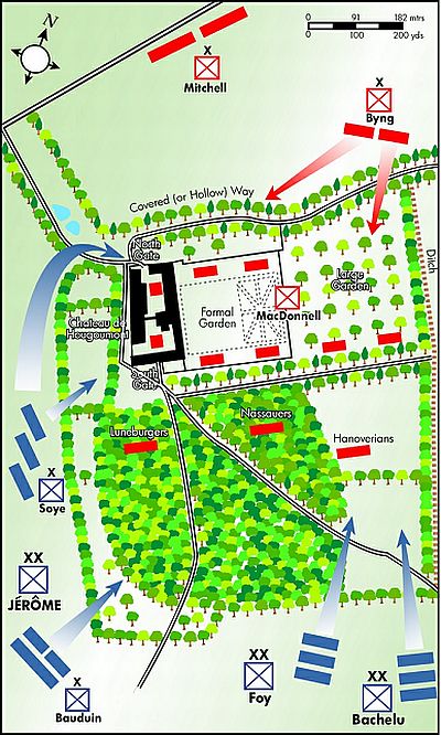
Hougoumont Farm layout
A long question and answer session followed. Mr van Oordt thanked our chairman who had assisted him in making the final choice of battlefield to visit and who had provided much useful information and support. The Chairman thanked Ms Castle and Mr van Oordt for two fascinating, well-illustrated and informative talks and presented them with the customary gifts.
MEMBERS
FORTHCOMING MEETINGS
10 NOVEMBER 2016: ANNUAL OVERVIEW OF THE SECURITY SITUATION IN AFRICA by Maj Helmoed Römer-Heitman
Major Heitman's annual overview of the security situation in Africa has never failed in the past to draw a full-house as far as attendance is concerned - this year it certainly would be no less so, in view of the continuing unstable political situation and economic turmoil in many an African state. As with his previous lectures, he will start the evening with a short introductory talk. He has indicated that he would like to discuss the current situation in the South China Sea.
This will be the final lecture in the year's programme. Make sure you don't miss it.
The lecture will be illustrated.
DECEMBER: Recess
No lectures are scheduled for December as the Cape Town Branch will be in recess in view of the upcoming summer holiday/festive season at the end of the year. The Branch will routinely commence with its activities on the third Thursday of January, the date being the 19th of January, 2017.
19 JANUARY 2017: CLASH OF THE IRONCLADS - TRACING THE DEVELOPMENT HISTORY FROM THE GALLEY TO THE STEAMSHIP, by Marius van der Merwe
Fellow-Member Marius van der Merwe's maiden lecture to the Society's Cape Town Branch, will trace the use of "armour" from ancient times to the modern age. This development - spanning millennia - culminated during the 2nd half of the 19th Century in the development and the first use of steel plating as a means of armouring naval ships to withstand artillery shelling. This signal event is enshrined in the history of naval warfare as the so-called steel-armoured "ironclads", first used in anger during the "War between the States" - the American Civil War. This was the historic naval duel between the Confederate States Navy's CSS Virginia and the United States Navy's USS Monitor during a four-hour engagement at the Battle of Hampton Roads on the 9th of March, 1862.
In his lecture our speaker will highlight the salient points of warship development from ancient times to the present. The use of Galleys (rowing ships) and the different methods of engaging enemy ships will focus on ramming as the principal method of destroying an enemy ship from about 800 BC until 900 AD when the use of artillery on board warships became common and made ramming redundant. This was followed by the age of sail and subsequently by steam as the primary means of propulsion while ship-board artillery - from muzzle- to breechloading - remained the main means of naval offensive/defensive weaponry. The lecture will be illustrated.
BOB BUSER: Treasurer/Asst. Scribe
Phone: 021-689-1639 (Home)
Email: bobbuser@webafrica.org.za
RAY HATTINGH: Secretary
Phone: 021-592-1279 (Office)
Email: ray@saarp.net